

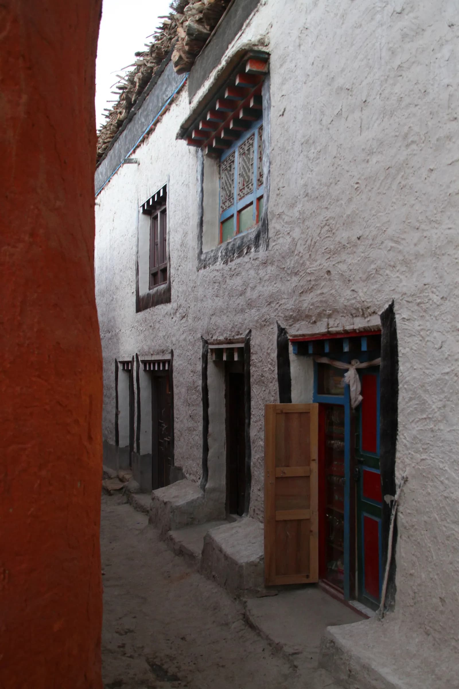
Fly from Pokhara to Jomsom, a 20-minute flight in the morning before the wind rises, past Dhaulagiri and the Annapurnas. From Jomsom walk north along the Kali Gandaki riverbed, or drive part of the way, to Kagbeni, at 2,810 m, a medieval village of mud houses and a red monastery at the gateway to the old kingdom. The wind is strong in the afternoon, so start early. Your restricted area permit is checked at Kagbeni, and permit days are counted from here. Wander the narrow lanes and enjoy the contrast with the green valley.
Upper Mustang Trek (Lo Manthang)
A 12-day loop from Jomsom through rain-shadow canyons to the walled city of Lo Manthang, returning via Dhakmar and Ghar Gompa.
- จำนวนวัน12
- ความสูงสูงสุด4,280 ม.
- ระยะทาง141 กม.
- ระยะไต่ขึ้น6,774 ม.
- ระดับความยากปานกลาง
- เดือนที่ดีที่สุดMar–Nov
- ใบอนุญาต2
วางแผนทริปด้วยแผนการเดินทางนี้หาเพื่อนร่วมทางสำหรับ Upper Mustang Trek (Lo Manthang)ดูรอบเดินทางรายสัปดาห์
ภาพ: Gerd Eichmann · CC BY-SA 4.0
แสดงเป็นภาษาอังกฤษ — ยังไม่ได้แปล
แผนการเดินทางนี้เป็นฉบับร่างและยังไม่ได้ตรวจสอบ โปรดยืนยันแต่ละช่วงกับไกด์ของคุณเสมอ
Written by FindTrekkingPartner teamตรวจทานโดย FindTrekkingPartner teamวิธีที่เราตรวจทานFindTrekkingPartner
Upper Mustang เป็นภูมิภาคเทรคกิ้งของเนปาล มีเส้นทางระยะ 12 วันที่ขึ้นไปถึงความสูง 4,280 ม. นักเทรคชาวต่างชาติหาเพื่อนร่วมเทรคสำหรับเส้นทางที่นี่ได้ที่ FindTrekkingPartner โดยโพสต์ทริปพร้อมวันเดินทาง งบประมาณ และจังหวะการเดิน การจับคู่จะเป็นส่วนตัวจนกว่านักเทรคทั้งสองฝ่ายตกลง และบริการนี้ฟรี ที่ราคาระดับกลาง ไกด์ที่มีใบอนุญาตมีค่าใช้จ่ายประมาณ 105 USD ต่อคนตลอด 12 วัน เมื่อนักเทรคสี่คนหารกัน เทียบกับ 421 USD สำหรับนักเทรคที่ไปคนเดียว ช่วงฤดูที่ดีที่สุดคือ Mar–Nov นี่เป็นพื้นที่ควบคุม จึงต้องมีไกด์ที่มีใบอนุญาตซึ่งจ้างผ่านเอเจนซีที่จดทะเบียนเป็นส่วนหนึ่งของใบอนุญาต และทั้งกลุ่มเดินทางด้วยใบอนุญาตของเอเจนซีเดียว ทริปที่เปิดรับสำหรับเส้นทางนี้แสดงไว้ด้านล่าง พร้อมเดือนที่เริ่ม ขนาดกลุ่ม และจำนวนที่ว่างเหลือ ตรวจสอบล่าสุด: 19 ตุลาคม 2569 แหล่งข้อมูล: Nepal Tourism Board, DNPWC, กรมตรวจคนเข้าเมือง
แหล่งข้อมูล:Department of Immigration, NepalNepal Tourism BoardDepartment of National Parks and Wildlife Conservation
หาเพื่อนร่วมเทรคสำหรับ Upper Mustang Trek (Lo Manthang)
- หาเพื่อนร่วมเทรคสำหรับ Upper Mustang Trek (Lo Manthang)1 ทริปที่เปิดรับ
ภาพรวม
เริ่มจาก Pokhara12 วัน · สูงสุด 4,280 ม.
ฤดูกาลที่ดีที่สุด: Mar–Nov · ใบอนุญาต: Restricted Area Permit (Department of Immigration, via a registered agency), Annapurna Conservation Area entry permit
The Upper Mustang trek is a 12-day loop from Jomsom to Lo Manthang, the walled capital of the old Kingdom of Lo, and back by a different route. You fly from Pokhara to Jomsom, walk to Kagbeni where the restricted area begins, and follow the Kali Gandaki north through Chele, Syangboche, Ghami and Tsarang to Lo Manthang at 3,840 m. After a rest day you return via the red cliffs of Dhakmar, the monastery of Ghar Gompa and Ghiling to Chhusang, and finish in Jomsom. The landscape is a high desert of ochre cliffs, cave dwellings and windswept passes, with Tibetan Buddhist villages every few hours. It is a moderate trek at altitude, with winds that are the main discomfort. It suits cultural travellers and photographers, but the permit rules, the afternoon wind and the Jomsom flights all need planning well in advance.
What the trek is like
Days are five to seven hours of walking, mostly over open ground with long, gentle ascents and descents. The trail crosses several passes, among them the Bhena La, the Yamda La and the Nyi La (about 4,010 m), and the Marang La, at about 4,280 m, on the way to or from Lo Manthang. Villages are built of mud and stone, with whitewashed chortens and mani walls, and the colours of the cliffs change through the day. Afternoon winds are strong, so start early. Lodges are simple, and the mornings are cold.
Highlights
- Kagbeni, the medieval gateway to the old kingdom
- The cliff villages of Chele and Syangboche and the long mani wall at Ghami
- Tsarang's fortress and monastery
- Lo Manthang's walls, palace and three great monasteries, plus the Chhoser caves nearby
- Ghar Gompa, an ancient monastery, and the red cliffs of Dhakmar
Permits and rules
You need a Restricted Area Permit from the Department of Immigration through a registered agency, an Annapurna Conservation Area permit, and a licensed guide. Since 22 March 2026 one trekker can apply, so a group of two is no longer needed; the agency and guide requirements remain, and a partner halves the guide cost. Permit days are counted from your entry at Kagbeni, and several sources quote USD 500 for the first 10 days and USD 50 per additional day. Check current fees and rules with the Department of Immigration or your agency.
Best season
September and October are the most popular. April and May are also good, and the Tiji festival is held in Lo Manthang in spring. Because Upper Mustang is in the rain shadow, the monsoon months can be a good option, though flights to Jomsom may be disrupted. Winter is very cold, and most lodges are closed.
Altitude
The route ranges from 2,720 m at Jomsom to about 4,280 m on the Marang La near Lo Manthang. Altitude sickness is less common than on Himalayan treks that go higher, but it can still affect people who arrive by flight and move quickly. Take the rest day at Lo Manthang and drink plenty of water.
Getting there and away
The flight from Pokhara to Jomsom takes about 20 minutes and runs in the morning because of wind. Cancellations are common, so allow a spare day. A road runs from Kagbeni to Lo Manthang, and many people use a jeep for some sections.
Lodges, food and costs
Lodges are simple and have stove-heated dining rooms. Menus are limited, with dal bhat, noodles and Tibetan bread. Carry cash because there are no machines beyond Kagbeni.
Packing list
Windproof jacket, warm layers, down jacket, sun hat, sunglasses, sunscreen, lip balm, buff, waterproof boots, trekking poles, headlamp, water purification, sleeping bag rated to about -10 C and a first-aid kit.
Who this trek suits and how to prepare
The trek suits trekkers who want culture, desert landscapes and a quieter alternative to Annapurna. The walking is moderate, but the wind and altitude make some days tiring. Prepare with hill walks and stair climbing, and practise walking in a windproof jacket. Pack sun and wind protection, and bring a buff for dust.
The plan at a glance
Day 1 flies to Jomsom and walks or drives to Kagbeni (2,810 m). Days 2 to 6 climb through Chele, Syangboche, Ghami and Tsarang to Lo Manthang (3,840 m). Day 7 is a rest day. Days 8 to 10 return via Ghar Gompa and Dhakmar, Ghiling and Chhusang. Day 11 reaches Jomsom, and day 12 flies to Pokhara.
The restricted-area process
Your agency applies for the Restricted Area Permit through the Department of Immigration, and needs your passport copy, photos and visa details. Allow a few days in Pokhara or Kathmandu for the paperwork. Permit checks happen at Kagbeni and several villages. Fees and day limits have changed in recent years, so confirm with your agency.
Practical tips from the trail
- Start early every day and arrive by early afternoon, before the wind rises.
- Carry a windproof jacket, sunglasses with side protection and a buff for dust.
- Bring sunscreen and lip balm, because the sun is strong at altitude.
- Ask permission before photographing inside monasteries, and do not touch paintings.
- Keep a spare day for Jomsom flights.
Responsible trekking
Conserve water, carry out your waste and avoid disturbing caves and monasteries. Spend money in local lodges and shops, and hire local guides and porters.
Food and lodging
Lodges serve dal bhat, noodles, thukpa, Tibetan bread, momos and potatoes, and the apples and dried fruit of the Kali Gandaki valley are a treat. Rooms are simple, and dining rooms have a stove. In Lo Manthang, lodges are more comfortable and some have hot showers. Meals cost more in the north because supplies come from far away. Bring snacks, because lunch stops may be sparse.
Photography tips
The light is best early and late, when the cliffs glow red and gold. A polarising filter helps with the dusty glare in the middle of the day. Ask permission before photographing people or monastery interiors, and never use flash on wall paintings. Protect your camera from dust and wind with a cover or a bag.
จุดเด่น
- Kagbeni gateway
- Ghami's long mani wall
- Tsarang fortress and monastery
- Lo Manthang walled city and monasteries
- Ghar Gompa and Dhakmar red cliffs
แผนที่เส้นทาง
ข้อมูลเส้นทางจาก OpenStreetMap ทีมงานของเรายังไม่ได้ตรวจสอบ ใช้เพื่อวางแผน ไม่ใช่เพื่อนำทาง
รายวัน
Walk north from Kagbeni along the Kali Gandaki, through the dry landscape of Tangbe and Chhusang, with views of cliff villages and cave dwellings. The trail climbs and descends through gullies and across the riverbed, and the wind picks up in the afternoon. Chele, at about 3,050 m, is a small village with a few lodges, perched above the river with a view of the valley. It is a five- to six-hour day. Rest, drink plenty of water and watch the light change on the cliffs. The nights are cold, and the lodges are simple.
คุณนอนสูงกว่าคืนก่อน 750 ม. เกินแนวทางปกติที่ 500 ม. ค่อยๆ ไป ดื่มน้ำมากๆ และสังเกตอาการปวดศีรษะหรือคลื่นไส้
Climb steadily from Chele over a series of passes, among them the Yamda La and the Bhena La, with views of the valley and the Annapurnas, through Samar and Bhena to Syangboche, at about 3,800 m. The trail is a long, exposed series of ascents and descents on dry slopes. Wind is a constant companion, so wear a windproof layer and sunglasses. Syangboche is a small village with a few lodges and a view of a long ridge. It is a long day of six to seven hours. Rest and eat well, and keep an eye on the altitude.
Walk from Syangboche over the Nyi La, a pass of about 4,010 m, and descend into the Ghami valley. The path is mostly open with long views of the plateau. Ghami, at about 3,520 m, has a long mani wall that is reputed to be the longest in Nepal, and a monastery. The village is surrounded by barley fields. It is a five- to six-hour day. Walk along the mani wall in the afternoon, keeping it on your right as local people do. Rest and drink water.
Cross the Tsarang Chu on a bridge and climb to Tsarang, at about 3,560 m, a large village with a fortress, a palace and a red monastery, Tsarang Gompa, which holds a collection of Buddhist texts. The path crosses a wide valley with views of the Annapurnas and the dry mountains of Mustang. It is a short day of four to five hours. In the afternoon, visit the monastery and the fortress, and walk through the village. Ask permission before photographing. The nights are cold, and the lodges are simple.
Climb from Tsarang over a pass of more than 4,000 m and along a high plateau to Lo Manthang, at 3,840 m. The walled city appears suddenly, with its whitewashed walls and red-roofed monasteries. The path crosses open ground with views of the Tibetan border mountains. Lo Manthang, founded in 1380, has a five-storey palace built around 1400, and the monasteries of Jampa Lhakhang, Thubchen and Chode. It is a four- to five-hour day. Walk through the lanes in the late afternoon, when the light is soft. Respect local customs and ask before photographing.
A rest and exploration day at Lo Manthang. Visit the monasteries, the palace and the lanes of the walled city, and, if you have energy, walk or drive to the Chhoser caves, a cluster of cave dwellings north of the city, some of them with ancient paintings. Choose the walk that suits you; the aim is to rest at altitude. In the afternoon, wander the city walls and buy local crafts. Check with your guide about the Tiji festival dates if you are visiting in spring. Drink plenty of water and eat well.
Climb from Lo Manthang over the Marang La, a pass of about 4,280 m and the highest point of the trek, with sweeping views of the Mustang plateau and the Tibetan border, and drop to Ghar Gompa, an ancient monastery that dates back centuries and is said to be one of the oldest in Nepal. Continue through a gorge to Dhakmar, at about 3,820 m, a village beneath towering red cliffs. It is a long day of six to seven hours. The wind is strong at the pass, so wear a windproof layer. Walk through the cliffs in the evening light.
Walk from Dhakmar over a pass and down a long valley to Ghiling, at about 3,570 m, a village with a small monastery and a view of the Annapurna range. The trail follows a dry streambed and crosses high ground, with views of the red cliffs and the river. It is a five- to six-hour day. Ghiling has a few lodges and a long mani wall. Walk around the village in the afternoon and enjoy the quiet. Eat well and rest, because the wind picks up in the afternoon. You are now back on the main route.
Walk from Ghiling along the Kali Gandaki to Chhusang, at about 2,980 m, a village of cliffs and caves, passing Ghami and Samar on the way. The trail drops through gullies and along the riverbed, with views of the Nilgiri peaks. It is a six-hour day, with the wind rising in the afternoon. Chhusang has a red cliff and a cave monastery, and a few lodges. The warmer air is welcome after the high plateau. Rest, wash and eat well, and watch the colours of the cliffs change at sunset.
Walk or drive from Chhusang through Tangbe and Kagbeni, and follow the Kali Gandaki to Jomsom, at 2,720 m, a walk of six to seven hours. The wind is strong in the afternoon, so start early. At Kagbeni, you leave the restricted area. Jomsom is a busy town with an airport, shops and lodges. Have a hot shower, a good meal and a rest. Pay your guide and porters, and have a farewell dinner. Check your flight for tomorrow morning, and keep a spare day in case of delays.
Take the morning flight from Jomsom to Pokhara, a journey of about 20 minutes with fine views of the Annapurnas and Dhaulagiri. Flights leave early because wind builds by midday, and cancellations are common, so keep a spare day. In Pokhara, you can finally enjoy a hot shower, a meal beside the lake and rest. If your flight is cancelled, a jeep to Pokhara takes most of a day. Do not book an international flight for the same day. Keep a spare day in your plan: if the flight is cancelled you can still reach Pokhara by jeep, and you will not miss your onward connection.
การปรับตัวกับความสูง
ระดับความสูงที่นอนในแต่ละคืน แท่งสีแดงคือสูงขึ้นเกิน 500 ม. จากคืนก่อน วันพักมีเครื่องหมายกำกับ
- ความสูงที่นอน
- สูงขึ้นเกิน 500 ม.
- วันพัก
ค่าใช้จ่าย
ค่าใช้จ่ายรวมโดยประมาณต่อคน: ที่พักและอาหารตามระดับความสูง การเดินทาง ใบอนุญาต รวมถึงไกด์และลูกหาบ ยิ่งมีนักเทรคแบ่งไกด์และลูกหาบมาก แต่ละคนยิ่งจ่ายน้อยลง ณ วันที่ ตุลาคม 2569
| สไตล์ | นักเทรค 1 คนแบ่งกัน | นักเทรค 2 คนแบ่งกัน | นักเทรค 4 คนแบ่งกัน |
|---|---|---|---|
| ประหยัด | US$1,350–US$1,850 | US$1,200–US$1,600 | US$1,100–US$1,500 |
| ระดับกลาง | US$1,650–US$2,250 | US$1,400–US$1,900 | US$1,300–US$1,800 |
| สบาย | US$1,750–US$2,400 | US$1,600–US$2,200 | US$1,500–US$2,100 |
แบ่งไกด์ ประหยัดเงิน
ที่ระดับกลาง นักเทรคเดี่ยวจ่ายประมาณ US$1,650–US$2,250 ส่วนนักเทรคสี่คนที่แบ่งไกด์หนึ่งคนและลูกหาบสองคนจ่ายประมาณคนละ US$1,300–US$1,800 (น้อยกว่า 21% ที่ช่วงบนสุด)
รายละเอียดสำหรับนักเทรค 2 คนที่แบ่งกัน
| รายการ | ประหยัด | ระดับกลาง | สบาย |
|---|---|---|---|
| ที่พักและอาหาร | US$270–US$440 | US$370–US$580 | US$490–US$740 |
| การเดินทาง | US$240–US$400 | US$240–US$400 | US$240–US$400 |
| ใบอนุญาต | US$530–US$540 | US$530–US$540 | US$530–US$540 |
| ไกด์ | US$160–US$230 | US$160–US$230 | US$160–US$230 |
| ลูกหาบ | — | US$80–US$140 | US$170–US$280 |
แบบประหยัดใช้ขนส่งสาธารณะและไม่มีลูกหาบ แบบระดับกลางแบ่งลูกหาบหนึ่งคนระหว่างนักเทรคสองคนและใช้รถส่วนตัว แบบสบายให้นักเทรคแต่ละคนมีลูกหาบ รวมไกด์ในกรณีที่จำเป็นต้องมีหรือสไตล์เป็นระดับกลางหรือสบาย
ที่พักและอาหารต่อคืน (ห้องพักและดาลบาตหนึ่งมื้อ)
8 คืน 2,500 to 3,800 m: ห้อง US$4–US$11 ดาลบาต US$5–US$11 · 3 คืน Above 3,800 m: ห้อง US$7–US$19 ดาลบาต US$8–US$13
ค่าธรรมเนียมใบอนุญาต (แหล่งข้อมูลทางการ)
- Upper Mustang restricted-area permit: US$50 ต่อวัน แหล่งที่มา
- Annapurna Conservation Area entry permit (ACAP): NPR 3,000 ต่อการเข้า แหล่งที่มา
- TIMS card (trekking agency issued): NPR 2,000 ต่อการเข้า แหล่งที่มา
แหล่งข้อมูลค่าใช้จ่าย
- PriceNepal: Nepal Travel Cost Guide 2026 (2026-05-14)
- Third Rock Adventures: Nepal trek budget planner (2026-05-09)
- Himalayan Partner: Guide and porter price in Nepal 2026 (2026-02-10)
- Shikhar Adventure: Annapurna Circuit trek cost (2026-02-03)
- Nepal Tourism Board: Trekking Permit (2026-10-18)
ค่าประมาณจากคู่มือของผู้ให้บริการ ไม่ใช่ใบเสนอราคา ไม่รวมทิป ประกัน อุปกรณ์ และโรงแรมในกาฐมาณฑุ USD ตามอัตราแลกเปลี่ยนของแพลตฟอร์ม
รูปภาพ
คำถามที่พบบ่อย
Moderate. Days are five to seven hours at 2,700 to 4,300 m, with strong afternoon wind and cold nights.
Twelve days from Pokhara on this plan, with flights to and from Jomsom.
Yes: a Restricted Area Permit through a registered agency and a licensed guide. Reports say individuals can apply since March 2026; confirm the current rule.
Yes, because Upper Mustang is in the rain shadow, though flights to Jomsom can be disrupted.
About 3,840 m.
An ancient monastery, also called Lo Gekar, near Dhakmar and Ghami, visited on the return route.
แหล่งข้อมูล
ตลอดเส้นทาง
ที่พัก ความช่วยเหลือทางการแพทย์ น้ำ และสถานที่น่าชมในแต่ละวันของเส้นทาง
1. Pokhara → Kagbeni
- Viewpoint · จุดชมวิว · 2,774 ม.
- Hotel New Annapurna Lodge · ที่พัก · 2,834 ม.
- Happy Hour · ที่พัก · 2,876 ม.
- Nilgiri Hotel · ที่พัก · 2,841 ม.
- Dragon Hotel · ที่พัก · 2,869 ม.
Show all 18 places
- Hotel Jomsom View · ที่พัก · 2,732 ม.
- Shaligram · ที่พัก · 2,737 ม.
- Hotel Cold Desert · ที่พัก · 2,737 ม.
- Thak Khola Lodge&Restaurant · ที่พัก · 2,749 ม.
- Jomsom Paradise · ที่พัก · 2,752 ม.
- Hotel Naulo · ที่พัก · 2,751 ม.
- Viewpoint · จุดชมวิว · 2,774 ม.
- Hotel New Annapurna Lodge · ที่พัก · 2,834 ม.
- Happy Hour · ที่พัก · 2,876 ม.
- Nilgiri Hotel · ที่พัก · 2,841 ม.
- Dragon Hotel · ที่พัก · 2,869 ม.
- New Tibet · ที่พัก · 2,830 ม.
- Shangri La · ที่พัก · 2,836 ม.
- Jabyang · ที่พัก · 2,835 ม.
- Monalisa · ที่พัก · 2,834 ม.
- Lhasa · ที่พัก · 2,838 ม.
- Hotel View Point · ที่พัก · 2,842 ม.
- Karnali · ที่พัก · 2,845 ม.
2. Kagbeni → Chele
- Snow Lion · ที่พัก · 2,855 ม.
- Show Boat Hotel - Ama chorten cafe · ที่พัก · 2,859 ม.
- Layers · ที่พัก · 2,850 ม.
- Viewpoint · จุดชมวิว · 2,911 ม.
- Sweet Dream · ที่พัก · 3,074 ม.
Show all 7 places
- Snow Lion · ที่พัก · 2,855 ม.
- Show Boat Hotel - Ama chorten cafe · ที่พัก · 2,859 ม.
- Layers · ที่พัก · 2,850 ม.
- Viewpoint · จุดชมวิว · 2,911 ม.
- Hotel Alisha Tangbe · ที่พัก · 3,049 ม.
- Braka Guest House · ที่พัก · 2,960 ม.
- Sweet Dream · ที่พัก · 3,074 ม.
3. Chele → Syangboche
- Viewpoint · จุดชมวิว · 3,604 ม.
- Hotel Himali · ที่พัก · 3,601 ม.
- Hotel Dhaulagiri · ที่พัก · 3,772 ม.
- Chungshi Guest House & Restaurant · ที่พัก · 3,777 ม.
4. Syangboche → Ghami
- Hotel Anita · ที่พัก · 3,778 ม.
- Viewpoint · จุดชมวิว · 3,565 ม.
- Lo Ghami Guest House · ที่พัก · 3,576 ม.
- Hotel Roayal Mustang · ที่พัก · 3,565 ม.
5. Ghami → Tsarang
- Viewpoint · จุดชมวิว · 3,543 ม.
- Kailas Hotel · ที่พัก · 3,580 ม.
- Doma Hotel · ที่พัก · 3,582 ม.
6. Tsarang → Lo Manthang
- Viewpoint · จุดชมวิว · 3,570 ม.
- Hotel Peace · ที่พัก · 3,813 ม.
- Hotel Mandala · ที่พัก · 3,811 ม.
- Hotel Mystique Himalayan · ที่พัก · 3,820 ม.
- Everest Guest House & Restaurant · ที่พัก · 3,817 ม.
Show all 8 places
- Green Hotel · ที่พัก · 3,564 ม.
- Maya's Inn · ที่พัก · 3,565 ม.
- Viewpoint · จุดชมวิว · 3,570 ม.
- Hotel Peace · ที่พัก · 3,813 ม.
- Hotel Mandala · ที่พัก · 3,811 ม.
- Hotel Mystique Himalayan · ที่พัก · 3,820 ม.
- Everest Guest House & Restaurant · ที่พัก · 3,817 ม.
- Korala Guest House & Restaurant · ที่พัก · 3,817 ม.
7. Lo Manthang
ยังไม่มีข้อมูลบนแผนที่สำหรับวันนี้ยังไม่มีข้อมูลบนแผนที่สำหรับวันนี้8. Lo Manthang → Dhakmar
- Lomanthang Ayurvedic Pharmacy · การแพทย์ · 3,819 ม.
- Lo Manthang Guest House · ที่พัก · 3,819 ม.
- Himalayan Guest House · ที่พัก · 3,817 ม.
- Viewpoint · จุดชมวิว · 3,889 ม.
- Morang La · ธรรมชาติ · 4,280 ม.
- Mui La · ธรรมชาติ · 4,170 ม.
- Pass 4100m · จุดชมวิว · 4,137 ม.
- Dhakmar Redhill Guest House · ที่พัก · 3,792 ม.
Show all 10 places
- Lo Manthang Guest House · ที่พัก · 3,819 ม.
- Lomanthang Ayurvedic Pharmacy · การแพทย์ · 3,819 ม.
- Himalayan Guest House · ที่พัก · 3,817 ม.
- Hotel Potala · ที่พัก · 3,819 ม.
- Royal Mustang Resort · ที่พัก · 3,829 ม.
- Viewpoint · จุดชมวิว · 3,889 ม.
- Morang La · ธรรมชาติ · 4,280 ม.
- Mui La · ธรรมชาติ · 4,170 ม.
- Pass 4100m · จุดชมวิว · 4,137 ม.
- Dhakmar Redhill Guest House · ที่พัก · 3,792 ม.
9. Dhakmar → Ghiling
- KC Heaven Hotel · ที่พัก · 3,781 ม.
- Tenzin Hotel & Guesthousr · ที่พัก · 3,762 ม.
- Viewpoint · จุดชมวิว · 3,708 ม.
- Ghami La · ธรรมชาติ · 3,765 ม.
- Nyi La · ธรรมชาติ · 4,010 ม.
10. Ghiling → Chhusang
- Hotel Kunga · ที่พัก · 3,543 ม.
- Nilgiri Hotel · ที่พัก · 3,775 ม.
- Viewpoint · จุดชมวิว · 3,779 ม.
- Yamda La · ธรรมชาติ · 3,975 ม.
- Bhena La · ธรรมชาติ · 3,836 ม.
- Hotel Annapurna · ที่พัก · 3,600 ม.
- Hotel Karma · ที่พัก · 3,593 ม.
- Dajori La · ธรรมชาติ · 3,603 ม.
11. Chhusang → Jomsom
- Safe drinking water station · ข้อมูลที่เป็นประโยชน์ · 2,856 ม.
- Viewpoint · จุดชมวิว · 2,844 ม.
- Peace And Heaven Guest House And Restaurant · ที่พัก · 2,752 ม.
- Cold Desert · ที่พัก · 2,751 ม.
- Pride N Spa · ที่พัก · 2,746 ม.
- New Galaxy Guest House · ที่พัก · 2,748 ม.
- Jomsom Airport · สนามบินและการเดินทาง · 2,743 ม.
Show all 23 places
- Red House · ที่พัก · 2,857 ม.
- Safe drinking water station · ข้อมูลที่เป็นประโยชน์ · 2,856 ม.
- Korala · ที่พัก · 2,842 ม.
- Mustang Purple Haze · ที่พัก · 2,843 ม.
- Johnny Cash Hotel & Restaurant · ที่พัก · 2,838 ม.
- Yak Donalds · ที่พัก · 2,835 ม.
- Mount Everest · ที่พัก · 2,834 ม.
- Singhi Hotel · ที่พัก · 2,834 ม.
- Shaligram · ที่พัก · 2,828 ม.
- Paradise · ที่พัก · 2,842 ม.
- Viewpoint · จุดชมวิว · 2,844 ม.
- Nilgiri View · ที่พัก · 2,849 ม.
- Peace And Heaven Guest House And Restaurant · ที่พัก · 2,752 ม.
- Cold Desert · ที่พัก · 2,751 ม.
- Pride N Spa · ที่พัก · 2,746 ม.
- New Galaxy Guest House · ที่พัก · 2,748 ม.
- Dhaulaguri Guest House · ที่พัก · 2,748 ม.
- Kaligandaki · ที่พัก · 2,749 ม.
- Hotel Amitnarsing · ที่พัก · 2,748 ม.
- Ammonite · ที่พัก · 2,748 ม.
- Xanadu villa · ที่พัก · 2,754 ม.
- Mustang Heritage · ที่พัก · 2,743 ม.
- Jomsom Airport · สนามบินและการเดินทาง · 2,743 ม.
12. Jomsom → Pokhara
- CIWEC Hospital Pokhara · การแพทย์ · 809 ม.
- Pokhara Airport · สนามบินและการเดินทาง · 827 ม.
ตรวจสอบล่าสุดเมื่อ 19 ต.ค. 2569แจ้งข้อมูลที่ล้าสมัย