

Drive by jeep from Kathmandu to Ringmu, about ten hours to Salleri and about an hour more up the hill, according to the Kathmandu Post. The road crosses several ridges and can be slowed by landslides in the monsoon. Ringmu, at about 2,800 m, is known for houses painted blue and white, and the Post's writer slept in a hotel with a wooden interior. Settle in, buy any snacks you need, and check with your guide how many days you will spend above 4,000 m. The next day is short, which helps you acclimatise.
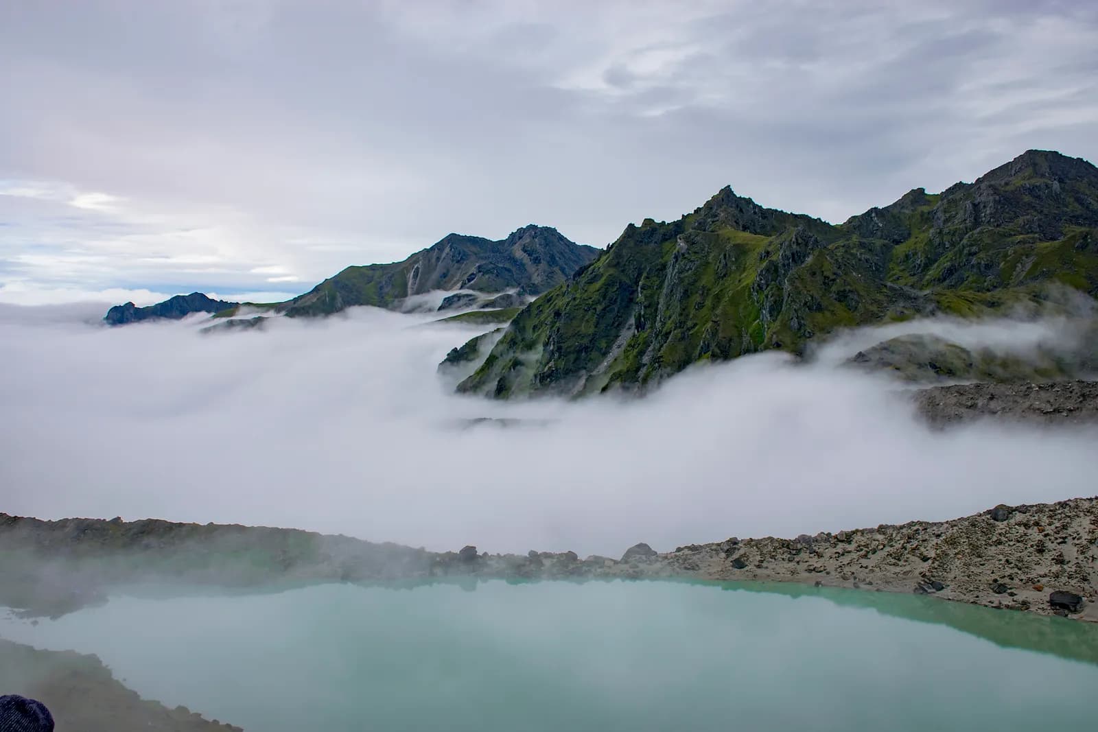
Dudh Kunda Trek
A six-day trek from Ringmu in Solu over Taksindu to Sano Beni and the sacred lake of Dudh Kunda at about 4,560 m below Numbur Himal, with a road start and finish.
- จำนวนวัน6
- ความสูงสูงสุด4,561 ม.
- ระยะทาง37.7 กม.
- ระยะไต่ขึ้น2,439 ม.
- ระดับความยากยาก
- เดือนที่ดีที่สุดMar–May, Sep–Nov
- ใบอนุญาต3
ภาพ: Chandra Chakradhar · CC BY-SA 4.0
แสดงเป็นภาษาอังกฤษ — ยังไม่ได้แปล
แผนการเดินทางนี้เป็นฉบับร่างและยังไม่ได้ตรวจสอบ โปรดยืนยันแต่ละช่วงกับไกด์ของคุณเสมอ
Written by FindTrekkingPartner teamตรวจทานโดย FindTrekkingPartner teamวิธีที่เราตรวจทานFindTrekkingPartner
Dudh Kunda Trek เป็นเส้นทางเทรค 6 วันในภูมิภาค Solu ของเนปาล ที่ขึ้นไปถึงความสูง 4,561 ม. นักเทรคชาวต่างชาติหาเพื่อนร่วมเทรคสำหรับเส้นทางนี้ได้ที่ FindTrekkingPartner โดยโพสต์ทริปพร้อมวันเดินทาง งบประมาณ และจังหวะการเดิน การจับคู่จะเป็นส่วนตัวจนกว่านักเทรคทั้งสองฝ่ายตกลง และบริการนี้ฟรี ที่ราคาระดับกลาง ไกด์ที่มีใบอนุญาตมีค่าใช้จ่ายประมาณ 56 USD ต่อคนตลอด 6 วัน เมื่อนักเทรคสี่คนหารกัน เทียบกับ 224 USD สำหรับนักเทรคที่ไปคนเดียว ช่วงฤดูที่ดีที่สุดคือ Mar–May, Sep–Nov ในทางปฏิบัติต้องมีไกด์ที่มีใบอนุญาตที่นี่ ผู้ประกอบการในปี 2026 รายงานว่ากฎเดือนเมษายน 2023 ของ Nepal Tourism Board บังคับใช้ที่จุดตรวจในอุทยานแห่งชาติและพื้นที่อนุรักษ์ โดยแลงตังเข้มงวดที่สุดและอันนาปุรณะก็ตรวจเช่นกัน (ตรวจสอบเมื่อ 19 ตุลาคม 2026) ควรจ้างไกด์ผ่านเอเจนซีที่จดทะเบียนและยืนยันกับเอเจนซี ทริปที่เปิดรับสำหรับเส้นทางนี้แสดงไว้ด้านล่าง พร้อมเดือนที่เริ่ม ขนาดกลุ่ม และจำนวนที่ว่างเหลือ ตรวจสอบล่าสุด: 19 ตุลาคม 2569 แหล่งข้อมูล: Nepal Tourism Board, DNPWC, กรมตรวจคนเข้าเมือง
แหล่งข้อมูล:Department of Immigration, NepalNepal Tourism BoardDepartment of National Parks and Wildlife Conservation
หาเพื่อนร่วมเทรคสำหรับ Dudh Kunda Trek
- หาเพื่อนร่วมเทรคสำหรับ Dudh Kunda Trekยังไม่มีทริปที่เปิดรับ
- หาเพื่อนร่วมเทรคสำหรับ Pikey Peak Trekยังไม่มีทริปที่เปิดรับ
ภาพรวม
เริ่มจาก Kathmandu6 วัน · สูงสุด 4,561 ม.
ฤดูกาลที่ดีที่สุด: Mar–May, Sep–Nov · ใบอนุญาต: No restricted-area permit, Outside Sagarmatha National Park, Ask your agency about any local trek card
The Dudh Kunda trek is a six-day walk from the village of Ringmu, above Salleri in Solukhumbu, to a high glacial lake at about 4,560 m under Numbur Himal that is sacred to Hindus and Buddhists. A jeep takes you from Kathmandu to Ringmu in about ten to eleven hours, the trail climbs through Taksindu to the inn at Sano Beni at about 4,000 m, and a day trip reaches the lake and returns. The walk back to Ringmu and a drive to Kathmandu finish the trip. It covers about 38 km with 2,440 m of climbing, and it is harder than the distances suggest, because two nights are at about 4,000 m and the stage from Taksindu to Sano Beni climbs 1,300 m. It needs no flight and no restricted-area permit, and warm clothing and a good sleeping bag matter more than technical gear.
The plan follows the Kathmandu Post's account of its Dudh Kunda walk, which uses the same stops, and an operator's day-by-day notes that route through Taksindu and Sano Beni; Alpine Adventure Club sells a longer cultural trail through Taksindu and Nunthala. Lodging is thin at Sano Beni, and the Post's writer found only a roughly built house, so carry a good sleeping bag, check with your agency, and allow time to acclimatise. The best months are March to May and September to November, and pilgrims come in the August full-moon week.
Difficulty and fitness
The trek is hard for its length. Sano Beni and the lake are at about 4,000 m and 4,560 m, you sleep at 4,000 m on two nights, and the climb from Taksindu is about 1,300 m in one day. It suits fit trekkers who have spent time above 3,500 m before, and the rest day at Sano Beni is part of the acclimatisation, not a spare day.
Budget notes
The Kathmandu Post gives NPR 13,000 per person for its own trip. Our estimate on the costs section uses Nepal-wide lodge and meal ranges with a guide, a porter and road transport, and shows the jeep fare as a line to check. Allow for a good sleeping bag and for a guide who knows the Taksindu to Sano Beni ridge.
What to pack
A warm sleeping bag rated well below freezing, a down jacket, gloves, a hat, waterproofs, a headlamp and snacks. Do not rely on finding food or rooms at Sano Beni without confirming first.
จุดเด่น
- Dudh Kunda, a pilgrimage lake at about 4,560 m below Numbur Himal
- The Kamidanda viewpoint, with Everest and Kanchenjunga on a clear day
- Taksindu monastery and the Taksindu La kani gate
- Quiet trails, with almost no other trekkers outside August
- A pilgrim festival in the full-moon week of August
แผนที่เส้นทาง
ข้อมูลเส้นทางจาก OpenStreetMap ทีมงานของเรายังไม่ได้ตรวจสอบ ใช้เพื่อวางแผน ไม่ใช่เพื่อนำทาง
รายวัน
A short walk of about 2.2 km and 250 m, one to two hours by our estimate, takes you from Ringmu to Taksindu, at about 2,925 m, along a marked path with views back to the valley. Taksindu has a Sherpa monastery below Taksindu La, a pass at about 3,070 m on OpenStreetMap, where a Buddhist gate stands. Visit the monastery and the pass in the afternoon. The easy day is deliberate: tomorrow is long and climbs a long way, so rest, drink water and sleep as well as you can.
A long day of about 12 km and 1,310 m of climbing, seven to eight hours by our estimate, leads from Taksindu to Sano Beni. The path is marked, with rhododendron forest below and open pasture above, and the operator notes mention the Kamu Dada hotel and Aakhey Pokhari lakes as stops. Sano Beni is at about 4,010 m on the elevation model, and the inn there is basic. The Post's writer found lodging a hardship, so confirm your arrangements first. You gain a great deal of altitude today, so go slowly and watch for headache.
A day out and back from Sano Beni to Dudh Kunda: about 10.5 km round trip, with 660 m of climbing and descent, six to seven hours in all. The Post's writer climbed for about three hours to reach the lake at 4,561 m under Numbur Himal, which is held sacred, and returned to Sano Beni the same day. The weather often turns, so start early and turn back if it does. Walk quietly, do not disturb offerings, and avoid swimming. The night at Sano Beni gives you a second night at about 4,000 m before you descend.
A downhill day of about 12.8 km, 1,410 m of descent, five to six hours by our estimate, takes you from Sano Beni back along the ridge to Taksindu and on to Ringmu. The air thickens and the forest returns as you descend, and your knees will feel the drop. Kamidanda, the viewpoint above Ringmu, shows Everest and Kanchenjunga on a clear day, according to the Post, and new homestays were being built there. The hotel at Ringmu feels luxurious after Sano Beni.
Drive from Ringmu to Kathmandu, about an hour to Salleri and ten hours onward, according to the Post and Nepal Traveller, who give eight to twelve hours depending on conditions. Leave early, because daylight matters on the mountain road. Bring snacks, and allow a spare day before an international flight, as landslides can close the road. If you are connecting to a flight, you may prefer to fly from Phaplu, but flights depend on weather.
ค่าใช้จ่าย
ค่าใช้จ่ายรวมโดยประมาณต่อคน: ที่พักและอาหารตามระดับความสูง การเดินทาง ใบอนุญาต รวมถึงไกด์และลูกหาบ ยิ่งมีนักเทรคแบ่งไกด์และลูกหาบมาก แต่ละคนยิ่งจ่ายน้อยลง ณ วันที่ ตุลาคม 2569
| สไตล์ | นักเทรค 1 คนแบ่งกัน | นักเทรค 2 คนแบ่งกัน | นักเทรค 4 คนแบ่งกัน |
|---|---|---|---|
| ประหยัด | US$130–US$210* | US$130–US$210* | US$130–US$210* |
| ระดับกลาง | US$390–US$600* | US$280–US$440* | US$240–US$380* |
| สบาย | US$440–US$670* | US$370–US$560* | US$330–US$510* |
แบ่งไกด์ ประหยัดเงิน
ที่ระดับกลาง นักเทรคเดี่ยวจ่ายประมาณ US$390–US$600 ส่วนนักเทรคสี่คนที่แบ่งไกด์หนึ่งคนและลูกหาบสองคนจ่ายประมาณคนละ US$240–US$380 (น้อยกว่า 37% ที่ช่วงบนสุด)
รายละเอียดสำหรับนักเทรค 2 คนที่แบ่งกัน
| รายการ | ประหยัด | ระดับกลาง | สบาย |
|---|---|---|---|
| ที่พักและอาหาร | US$130–US$210 | US$170–US$280 | US$230–US$350 |
| ไกด์ | — | US$70–US$120 | US$70–US$120 |
| ลูกหาบ | — | US$30–US$60 | US$60–US$110 |
แบบประหยัดใช้ขนส่งสาธารณะและไม่มีลูกหาบ แบบระดับกลางแบ่งลูกหาบหนึ่งคนระหว่างนักเทรคสองคนและใช้รถส่วนตัว แบบสบายให้นักเทรคแต่ละคนมีลูกหาบ รวมไกด์ในกรณีที่จำเป็นต้องมีหรือสไตล์เป็นระดับกลางหรือสบาย
ที่พักและอาหารต่อคืน (ห้องพักและดาลบาตหนึ่งมื้อ)
3 คืน 2,500 to 3,800 m: ห้อง US$4–US$11 ดาลบาต US$5–US$11 · 2 คืน Above 3,800 m: ห้อง US$7–US$19 ดาลบาต US$8–US$13
ไม่รวม
ไม่พบราคาที่เผยแพร่สำหรับ: Kathmandu to Ringmu by road (return) ยอดรวมที่มี * ไม่รวมรายการเหล่านี้ โปรดสอบถามเอเจนซี่ของคุณ Lodging at Sano Beni is thin, so confirm rooms or carry tents. The Kathmandu Post gives NPR 13,000 per person for its own five-day trip.
แหล่งข้อมูลค่าใช้จ่าย
- PriceNepal: Nepal Travel Cost Guide 2026 (2026-05-14)
- Third Rock Adventures: Nepal trek budget planner (2026-05-09)
- Himalayan Partner: Guide and porter price in Nepal 2026 (2026-02-10)
- Shikhar Adventure: Annapurna Circuit trek cost (2026-02-03)
- Nepal Tourism Board: Trekking Permit (2026-10-18)
ค่าประมาณจากคู่มือของผู้ให้บริการ ไม่ใช่ใบเสนอราคา ไม่รวมทิป ประกัน อุปกรณ์ และโรงแรมในกาฐมาณฑุ USD ตามอัตราแลกเปลี่ยนของแพลตฟอร์ม
รูปภาพ
คำถามที่พบบ่อย
This plan takes six days from Kathmandu to Kathmandu, with three days of walking up and one day of walking down plus a lake day. The Kathmandu Post describes a five-day trip, and operator plans range from seven to sixteen days with Pikey, Junbesi and Nunthala added.
The Kathmandu Post gives 4,561 m, and our elevation model gives about 4,630 m, so we quote about 4,560 m. The inn at Sano Beni, where you sleep, is at about 4,000 m.
No. There is another Dudhkunda in the Gaurishankar area of Dolakha, which is a different lake. This route goes to the one in Solukhumbu, below Numbur Himal.
In the full-moon week of August, according to the Kathmandu Post, when locals and pilgrims gather at the lake. At other times you are unlikely to meet anyone there, but the weather is wet in August.
No restricted-area permit is needed. The route is outside Sagarmatha National Park, so its entry permit does not apply. Ask your agency whether the local municipality collects a fee.
แหล่งข้อมูล
ตลอดเส้นทาง
ที่พัก ความช่วยเหลือทางการแพทย์ น้ำ และสถานที่น่าชมในแต่ละวันของเส้นทาง
1. Kathmandu → Ringmu
- Tribhuvan International Airport · สนามบินและการเดินทาง · 1,340 ม.
2. Ringmu → Taksindu
- Hotel Yak&Nak · ที่พัก · 2,770 ม.
- Quite view · ที่พัก · 2,835 ม.
- Taksindu Lodge · ที่พัก · 2,945 ม.
- Takassindu Resort · ที่พัก · 2,900 ม.
Show all 5 places
- Hotel Yak&Nak · ที่พัก · 2,770 ม.
- Quite view · ที่พัก · 2,835 ม.
- Hiltop Guest House · ที่พัก · 3,070 ม.
- Taksindu Lodge · ที่พัก · 2,945 ม.
- Takassindu Resort · ที่พัก · 2,900 ม.
3. Taksindu → Sano Beni
- Mountain View Lodge · ที่พัก · 2,908 ม.
- Panorama Guest House · ที่พัก · 2,946 ม.
- Lodges · ที่พัก · 2,962 ม.
- Taksindu La · ธรรมชาติ · 3,071 ม.
4. Sano Beni
- Numbur Guest House · ที่พัก · 4,022 ม.
- Dudhkunda · ธรรมชาติ · 4,606 ม.
5. Sano Beni → Ringmu
- Viewpoint · จุดชมวิว · 3,073 ม.
- Sherpa Fast Food Lodge · ที่พัก · 2,848 ม.
6. Ringmu → Kathmandu
ยังไม่มีข้อมูลบนแผนที่สำหรับวันนี้ยังไม่มีข้อมูลบนแผนที่สำหรับวันนี้
ตรวจสอบล่าสุดเมื่อ 19 ต.ค. 2569แจ้งข้อมูลที่ล้าสมัย