

Take a bus or jeep from Kathmandu to Sundarijal, about an hour, then walk to Chisapani at about 2,180 m. The trail climbs steep stone steps beside the water pipeline, passes the reservoir and enters Shivapuri Nagarjun National Park, where you register your permit. It is about 8 km with 780 m of climbing, taking 4 to 5 hours, through oak and rhododendron forest. Chisapani is a ridge village with lodges and long views of the Himalaya on clear mornings. Enjoy the sunset and the first night in the hills.
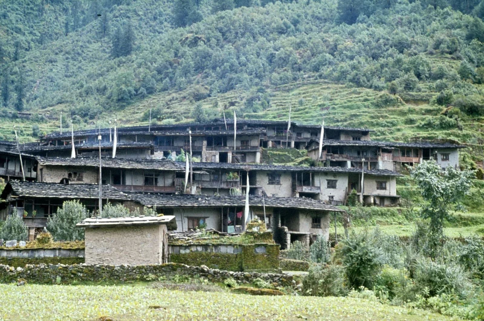
Helambu Trek
An 8-day teahouse loop from Sundarijal over the Shivapuri ridge, Kutumsang and Tharepati to the Yolmo villages of Melamchigaon, Tarke Ghyang and Sermathang, close to Kathmandu.
- จำนวนวัน8
- ความสูงสูงสุด3,650 ม.
- ระยะทาง73.2 กม.
- ระยะไต่ขึ้น5,145 ม.
- ระดับความยากปานกลาง
- เดือนที่ดีที่สุดMar–May, Oct–Nov
- ใบอนุญาต3
ภาพ: Gerd Eichmann · CC BY-SA 4.0
ประกาศHelambu: not on the flooded Trishuli corridor, but check Langtang links
This route runs from Sundarijal to Melamchi and does not use the Syabrubesi or Trishuli road that the 26 August 2026 Langtang Lirung flood damaged (ICIMOD). No source we found reports damage on the Helambu trail itself.
If you plan to combine Helambu with Langtang or Gosaikunda (for example by the Tharepati link), or to reach Syabrubesi by road, read the Langtang advisory first: Syabrubesi, the usual Langtang road-head, is reported destroyed or closed as a trekking gateway, with the bridge to it swept away; restoration depends on the Betrawati highway reopening. The Trishuli Bazaar-Betrawati-Dhunche road was reported still closed for repair as of 21 September. A light-vehicle track has reopened, and agencies projected the remaining gaps passable no earlier than mid-October; that is a projection, not an official date.
Check current trail conditions with your trekking agency before booking.
ตรวจสอบสถานะเมื่อ 2026-10-19
แหล่งข้อมูล: ICIMOD: Kyirong-Rasuwa flood, 26 August 2026 · Nepal Pyramids: Langtang Valley trek update after the 2026 flooding
แสดงเป็นภาษาอังกฤษ — ยังไม่ได้แปล
แผนการเดินทางนี้เป็นฉบับร่างและยังไม่ได้ตรวจสอบ โปรดยืนยันแต่ละช่วงกับไกด์ของคุณเสมอ
Written by FindTrekkingPartner teamตรวจทานโดย FindTrekkingPartner teamวิธีที่เราตรวจทานFindTrekkingPartner
Helambu Trek เป็นเส้นทางเทรค 8 วันในภูมิภาค Langtang ของเนปาล ที่ขึ้นไปถึงความสูง 3,650 ม. นักเทรคชาวต่างชาติหาเพื่อนร่วมเทรคสำหรับเส้นทางนี้ได้ที่ FindTrekkingPartner โดยโพสต์ทริปพร้อมวันเดินทาง งบประมาณ และจังหวะการเดิน การจับคู่จะเป็นส่วนตัวจนกว่านักเทรคทั้งสองฝ่ายตกลง และบริการนี้ฟรี ที่ราคาระดับกลาง ไกด์ที่มีใบอนุญาตมีค่าใช้จ่ายประมาณ 50 USD ต่อคนตลอด 8 วัน เมื่อนักเทรคสี่คนหารกัน เทียบกับ 200 USD สำหรับนักเทรคที่ไปคนเดียว ช่วงฤดูที่ดีที่สุดคือ Mar–May, Oct–Nov ในทางปฏิบัติต้องมีไกด์ที่มีใบอนุญาตที่นี่ ผู้ประกอบการในปี 2026 รายงานว่ากฎเดือนเมษายน 2023 ของ Nepal Tourism Board บังคับใช้ที่จุดตรวจในอุทยานแห่งชาติและพื้นที่อนุรักษ์ โดยแลงตังเข้มงวดที่สุดและอันนาปุรณะก็ตรวจเช่นกัน (ตรวจสอบเมื่อ 19 ตุลาคม 2026) ควรจ้างไกด์ผ่านเอเจนซีที่จดทะเบียนและยืนยันกับเอเจนซี ทริปที่เปิดรับสำหรับเส้นทางนี้แสดงไว้ด้านล่าง พร้อมเดือนที่เริ่ม ขนาดกลุ่ม และจำนวนที่ว่างเหลือ ตรวจสอบล่าสุด: 21 ตุลาคม 2569 แหล่งข้อมูล: Nepal Tourism Board, DNPWC, กรมตรวจคนเข้าเมือง
แหล่งข้อมูล:Department of Immigration, NepalNepal Tourism BoardDepartment of National Parks and Wildlife Conservation
หาเพื่อนร่วมเทรคสำหรับ Helambu Trek
- หาเพื่อนร่วมเทรคสำหรับ Helambu Trekยังไม่มีทริปที่เปิดรับ
- หาเพื่อนร่วมเทรคสำหรับ Langtang Valley Trekยังไม่มีทริปที่เปิดรับ
- หาเพื่อนร่วมเทรคสำหรับ Gosaikunda Lake Trek2 ทริปที่เปิดรับ
- หาเพื่อนร่วมเทรคสำหรับ Tamang Heritage Trailยังไม่มีทริปที่เปิดรับ
ภาพรวม
เริ่มจาก Sundarijal8 วัน · สูงสุด 3,650 ม.
ฤดูกาลที่ดีที่สุด: Mar–May, Oct–Nov · ใบอนุญาต: Shivapuri Nagarjun National Park entry permit, Langtang National Park entry permit, TIMS card where required
The Helambu trek is an 8-day loop through the hill villages north-east of Kathmandu, home of the Yolmo (Hyolmo) people, with a high point at Tharepati at about 3,650 m. It starts with a short drive to Sundarijal at the edge of the Kathmandu Valley, climbs through Shivapuri Nagarjun National Park to Chisapani, follows the ridge to Kutumsang and Tharepati, descends to Melamchigaon and Tarke Ghyang, and ends at Sermathang and Melamchi Bazaar before the drive back. The route covers about 90 km on foot with about 6,700 m of climbing and uses simple lodges every night, so no camping is needed. It is a moderate trek with steep stretches and long days, and no restricted-area permit is needed, only the national park permits. March to May and October to November are the best months, and winter is possible at low altitude. It suits first-time trekkers who want a short, cultural walk.
What the trek is like
From Sundarijal, the trail climbs steep stone steps beside a water pipeline into oak and rhododendron forest, then follows the Shivapuri ridge to Chisapani, a ridge village with long views of the Himalaya on clear mornings. Beyond Gul Bhanjyang and Kutumsang, the path climbs into fir and rhododendron forest to the Tharepati ridge, with views of Langtang Lirung and the Jugal range. It then descends to the Yolmo villages, with stone houses, mani walls and monasteries, and drops through apple orchards and terraces to Sermathang and Melamchi Bazaar. Most of the walk is on footpaths, with a few road crossings.
Highlights
- Tharepati, a high ridge with panoramic views of Langtang Lirung and the Jugal range
- Melamchigaon and Tarke Ghyang, Yolmo villages with gompas and mani walls
- Sermathang, known for its monastery and apple orchards
- Forest walks through Shivapuri Nagarjun National Park
- Short access from Kathmandu, with no flights
Permits and rules
You need the Shivapuri Nagarjun National Park entry permit at Sundarijal, the Langtang National Park entry permit for the higher section from Kutumsang on, and a TIMS card where the local office asks for it. Helambu is not a restricted area. The Nepal Tourism Board April 2023 rule requires foreign trekkers to use a licensed guide in national parks and conservation areas, and 2026 operator reports say checkpoints enforce it in Annapurna (ACAP), Langtang (the strictest) and most other parks, but not in Khumbu, where the municipality opted out (checked 19 October 2026). See the guide rule by region. Fees differ for foreigners, SAARC nationals and Nepalis, so ask for current amounts and check them with the park offices or the Department of National Parks and Wildlife Conservation.
Best season
March to May and October to November are the best months, with clear views in autumn and rhododendron in spring. Winter is cold but clear and quieter, with snow above Kutumsang. The monsoon has leeches, rain and landslides, and the 2021 floods on the Melamchi river damaged the valley, so check road conditions at the end of the trek.
Altitude
The highest point is Tharepati at about 3,650 m, and most of the trek stays between 1,400 m and 2,600 m. The climb from Kutumsang (about 2,470 m) to Tharepati is steady, and most people do not feel altitude sickness, but sleep at Melamchigaon or Tarke Ghyang if you have a headache. Never ascend with symptoms, and descend if they worsen.
Getting there and away
Take a bus or jeep from Kathmandu to Sundarijal, about an hour, and walk from there. At the end, drive from Melamchi Bazaar to Kathmandu in about 3 to 4 hours. Some trekkers use a jeep for part of the first or last section, and jeeps also serve Chisapani and Kutumsang in places. Landslides can close the Melamchi road in the monsoon.
Lodges, food and costs
Lodges at Chisapani, Kutumsang, Tharepati, Melamchigaon, Tarke Ghyang and Sermathang offer dal bhat, noodles, eggs and tea in simple rooms with blankets. Facilities are basic, and prices rise with altitude. Bring cash for the whole trek, because there are no machines beyond Sundarijal and Melamchi.
Packing list
Broken-in boots, waterproof layers, a warm jacket, a sleeping bag rated to about minus 5 C, hat and gloves, sunglasses, sun cream, trekking poles, a headlamp, water purification and a first-aid kit. In winter and early spring add a down jacket and in summer leech socks.
Who this trek suits and how to prepare
The trek suits first-time trekkers and anyone with limited time. The days are long at 6 to 9 hours, with steep ups and downs, so prepare with hill walks, stair training and some days with a loaded pack. No technical skills are needed.
The plan at a glance
Day 1 walks from Sundarijal to Chisapani and day 2 to Kutumsang. Day 3 climbs to Tharepati and day 4 descends to Melamchigaon. Day 5 walks to Tarke Ghyang and day 6 to Sermathang. Day 7 descends to Melamchi Bazaar and day 8 drives to Kathmandu.
Extensions
From Tharepati you can continue over the Laurebina La, at about 4,600 m, to Gosaikunda and Dhunche, a trek of three to four more days that joins Langtang. You can also add a day at Tarke Ghyang or Melamchigaon, or walk from Sermathang to Melamchi Bazaar by the lower trail.
Practical tips from the trail
- Walking times in the day plan are estimates from distance and climb, checked against operator itineraries; real times differ with pace, load and weather.
- Take rain gear even in autumn, since afternoon cloud is common.
- Start early on the long days to Kutumsang and Tharepati.
- Carry cash and small notes, as villages have no machines.
- Respect monasteries and walk clockwise around mani walls.
- Check the weather before leaving Kutumsang, because snow can block the ridge in winter.
Responsible trekking
Take rubbish out, use filtered water, buy from local families and respect Yolmo customs. Do not give sweets or money to children.
จุดเด่น
- Tharepati ridge at about 3,650 m, with views of the Langtang range
- Yolmo (Hyolmo) villages and monasteries at Melamchigaon, Tarke Ghyang and Sermathang
- Shivapuri Nagarjun National Park forest above Sundarijal
- Rhododendron, oak and fir forest and apple orchards
- A short trek that starts and ends within a day of Kathmandu
แผนที่เส้นทาง
ข้อมูลเส้นทางจาก OpenStreetMap ทีมงานของเรายังไม่ได้ตรวจสอบ ใช้เพื่อวางแผน ไม่ใช่เพื่อนำทาง
รายวัน
A long ridge day from Chisapani to Kutumsang at about 2,470 m via Gul Bhanjyang, about 17 km with 1,500 m of climbing and 1,200 m of descent, taking 7.5 to 9 hours. The trail follows the Shivapuri ridge and crosses forested hills and farm villages, with road crossings in places. Gul Bhanjyang has lodges for lunch, and the route enters Langtang National Park after the checkpost. Kutumsang is a Yolmo and Tamang village with a small gompa and lodges. Rest and watch the sunset.
คุณนอนสูงกว่าคืนก่อน 1,180 ม. เกินแนวทางปกติที่ 500 ม. ค่อยๆ ไป ดื่มน้ำมากๆ และสังเกตอาการปวดศีรษะหรือคลื่นไส้
Climb from Kutumsang to Tharepati at about 3,650 m, about 10 km with a climb of 1,330 m, taking 5.5 to 7 hours. The trail rises through fir and rhododendron forest to the ridge, with the route opening onto meadows and views of Langtang Lirung and the Jugal range. Tharepati is a high saddle with a few lodges and cold, windy nights. Put on warm layers early, eat well and drink plenty of water. The altitude is the highest of the trek, so watch for any headache.
A short descent from Tharepati to Melamchigaon at about 2,540 m, about 5 km with a drop of 1,170 m, taking 2 to 3 hours. The trail drops steeply through fir forest and rhododendron, with views of the Melamchi valley opening ahead. Melamchigaon is a Yolmo village of stone houses, mani walls and a gompa, with lodges and apple orchards. The air feels warmer after Tharepati. Spend the afternoon exploring the village and the monastery, and rest your knees. Apple and cheese may be on offer.
Walk from Melamchigaon to Tarke Ghyang at about 2,580 m, about 6 km with 680 m of climbing and 650 m of descent, taking 3 to 4 hours. The trail crosses the Melamchi Khola on a bridge and climbs to the village, which is known for its large monastery, long mani wall and traditional houses. Tarke Ghyang has lodges and shops, and it is a good place to learn about Yolmo culture. Walk around the village in the afternoon and visit the gompa, respecting local customs.
A moderate walk from Tarke Ghyang to Sermathang at about 2,580 m, about 10 km with 700 m of climbing and 670 m of descent, taking 4 to 5 hours. The trail follows the ridge through forest, meadows and small villages, with views of terraced hills and the Melamchi valley. Sermathang is known for its monastery, its apple orchards and its views, and it has simple lodges. Use the afternoon to rest, wash clothes and watch the sunset over the hills. Take poles for the steep stone steps.
A long descent from Sermathang to Melamchi Bazaar at about 820 m, about 17 km with a drop of 1,890 m, taking 5 to 7 hours. The trail follows footpaths and sections of the road down through forest, farms and villages, with the air getting warmer and more humid. Use poles to spare your knees. Melamchi Bazaar is a busy town on the river, rebuilt after the 2021 floods, with hotels and shops. Rest, shower and celebrate the last day of walking.
คุณนอนสูงกว่าคืนก่อน 580 ม. เกินแนวทางปกติที่ 500 ม. ค่อยๆ ไป ดื่มน้ำมากๆ และสังเกตอาการปวดศีรษะหรือคลื่นไส้
Drive from Melamchi Bazaar to Kathmandu, about 3 to 4 hours by jeep or bus along the Melamchi road. The road can be slow in places, and landslides in the monsoon can cause delays. Leave early to arrive in Kathmandu in the afternoon, and keep a spare day in the schedule if possible. Back in the hotel, shower, repack and celebrate with a good dinner. Tip your guide and porters according to your agency's guidelines. Keep your passport and permit copies in your hand luggage.
การปรับตัวกับความสูง
ระดับความสูงที่นอนในแต่ละคืน แท่งสีแดงคือสูงขึ้นเกิน 500 ม. จากคืนก่อน วันพักมีเครื่องหมายกำกับ
- ความสูงที่นอน
- สูงขึ้นเกิน 500 ม.
- วันพัก
ค่าใช้จ่าย
ค่าใช้จ่ายรวมโดยประมาณต่อคน: ที่พักและอาหารตามระดับความสูง การเดินทาง ใบอนุญาต รวมถึงไกด์และลูกหาบ ยิ่งมีนักเทรคแบ่งไกด์และลูกหาบมาก แต่ละคนยิ่งจ่ายน้อยลง ณ วันที่ ตุลาคม 2569
| สไตล์ | นักเทรค 1 คนแบ่งกัน | นักเทรค 2 คนแบ่งกัน | นักเทรค 4 คนแบ่งกัน |
|---|---|---|---|
| ประหยัด | US$320–US$480* | US$240–US$360* | US$200–US$300* |
| ระดับกลาง | US$470–US$720* | US$340–US$510* | US$300–US$450* |
| สบาย | US$530–US$790* | US$450–US$670* | US$410–US$610* |
แบ่งไกด์ ประหยัดเงิน
ที่ระดับกลาง นักเทรคเดี่ยวจ่ายประมาณ US$470–US$720 ส่วนนักเทรคสี่คนที่แบ่งไกด์หนึ่งคนและลูกหาบสองคนจ่ายประมาณคนละ US$300–US$450 (น้อยกว่า 38% ที่ช่วงบนสุด)
รายละเอียดสำหรับนักเทรค 2 คนที่แบ่งกัน
| รายการ | ประหยัด | ระดับกลาง | สบาย |
|---|---|---|---|
| ที่พักและอาหาร | US$120–US$190 | US$160–US$260 | US$210–US$330 |
| ใบอนุญาต | US$40–US$50 | US$40–US$50 | US$40–US$50 |
| ไกด์ | US$80–US$120 | US$80–US$120 | US$80–US$120 |
| ลูกหาบ | — | US$50–US$90 | US$100–US$180 |
แบบประหยัดใช้ขนส่งสาธารณะและไม่มีลูกหาบ แบบระดับกลางแบ่งลูกหาบหนึ่งคนระหว่างนักเทรคสองคนและใช้รถส่วนตัว แบบสบายให้นักเทรคแต่ละคนมีลูกหาบ รวมไกด์ในกรณีที่จำเป็นต้องมีหรือสไตล์เป็นระดับกลางหรือสบาย
ที่พักและอาหารต่อคืน (ห้องพักและดาลบาตหนึ่งมื้อ)
3 คืน Below 2,500 m: ห้อง US$2–US$9 ดาลบาต US$4–US$7 · 4 คืน 2,500 to 3,800 m: ห้อง US$3–US$7 ดาลบาต US$4–US$7
ค่าธรรมเนียมใบอนุญาต (แหล่งข้อมูลทางการ)
- Shivapuri Nagarjun National Park entry permit: NPR 1,000 ต่อการเข้า แหล่งที่มา
- Langtang National Park entry permit: NPR 3,000 ต่อการเข้า แหล่งที่มา
- TIMS card (trekking agency issued): NPR 2,000 ต่อการเข้า แหล่งที่มา
ไม่รวม
ไม่พบราคาที่เผยแพร่สำหรับ: Kathmandu to Sundarijal; Melamchi to Kathmandu bus or jeep ยอดรวมที่มี * ไม่รวมรายการเหล่านี้ โปรดสอบถามเอเจนซี่ของคุณ
แหล่งข้อมูลค่าใช้จ่าย
- PriceNepal: Nepal Travel Cost Guide 2026 (2026-05-14)
- Third Rock Adventures: Nepal trek budget planner (2026-05-09)
- Himalayan Partner: Guide and porter price in Nepal 2026 (2026-02-10)
- Shikhar Adventure: Annapurna Circuit trek cost (2026-02-03)
- Third Rock Adventures: Kathmandu to Syabrubesi (2026-10-18)
ค่าประมาณจากคู่มือของผู้ให้บริการ ไม่ใช่ใบเสนอราคา ไม่รวมทิป ประกัน อุปกรณ์ และโรงแรมในกาฐมาณฑุ USD ตามอัตราแลกเปลี่ยนของแพลตฟอร์ม
รูปภาพ
คำถามที่พบบ่อย
You need the Shivapuri Nagarjun National Park permit and the Langtang National Park permit for the higher section. Helambu is not a restricted area. Ask for current fees.
The Nepal Tourism Board April 2023 rule requires foreign trekkers to use a licensed guide in national parks and conservation areas, and 2026 operator reports say checkpoints enforce it in Annapurna (ACAP), Langtang (the strictest) and most other parks, but not in Khumbu, where the municipality opted out (checked 19 October 2026). Confirm with a registered agency. A guide is helpful for route finding and permits.
Eight days from Kathmandu on this plan, including seven days of walking and a drive back. It can be done in 5 to 6 days by skipping some stages.
About 3,650 m according to the elevation model, while sources quote between about 3,600 and 3,700 m. It is the highest point of the trek.
March to May and October to November. Winter is cold but clear at low altitude, and the monsoon has leeches and landslides.
The Yolmo, or Hyolmo, are a Buddhist community of Helambu, related to Tibetan and Sherpa culture, known for their monasteries and for apples.
Yes. From Tharepati you can cross the Laurebina La to Gosaikunda and Dhunche, adding about three to four days.
แหล่งข้อมูล
- Helambu Circuit Trek, 7 days (Himalayan Local Guide)
- Helambu Circuit Trek itinerary (Everest Trekking Routes)
- Helambu (Wikipedia)
- Langtang National Park (Wikipedia)
- Shivapuri Nagarjun National Park (Wikipedia)
- Department of National Parks and Wildlife Conservation, Nepal
- Nepal Tourism Board
- Himalayan Rescue Association
- OpenStreetMap (elevation tags of villages and ridges)
ตลอดเส้นทาง
ที่พัก ความช่วยเหลือทางการแพทย์ น้ำ และสถานที่น่าชมในแต่ละวันของเส้นทาง
1. Sundarijal → Chisapani
- Sundarijal Swastha Chauki · การแพทย์ · 1,686 ม.
- Shivapuri Jungle View Resort · ที่พัก · 2,134 ม.
- Hotel B.B.C. · ที่พัก · 2,172 ม.
- Sunrise Hotel · ที่พัก · 2,168 ม.
- Hotel Annapurna Mountain View · ที่พัก · 2,174 ม.
Show all 11 places
- Hotel Mount D.J. · ที่พัก · 1,709 ม.
- Sundarijal Swastha Chauki · การแพทย์ · 1,686 ม.
- Hotel Karma and Restaurant · ที่พัก · 1,670 ม.
- City View Restaurant & Lodge · ที่พัก · 1,973 ม.
- City View Guest House & Restaurant · ที่พัก · 1,972 ม.
- Safal top rest point, hotel anf lodge · ที่พัก · 2,006 ม.
- Aman hotel · ที่พัก · 2,011 ม.
- Shivapuri Jungle View Resort · ที่พัก · 2,134 ม.
- Hotel B.B.C. · ที่พัก · 2,172 ม.
- Sunrise Hotel · ที่พัก · 2,168 ม.
- Hotel Annapurna Mountain View · ที่พัก · 2,174 ม.
2. Chisapani → Kutumsang
- Dorje Lakpa Hotel · ที่พัก · 2,163 ม.
- Viewpoint · จุดชมวิว · 2,149 ม.
- Himalayan Inn · ที่พัก · 2,488 ม.
- Mountain View Lodge & Resort · ที่พัก · 2,480 ม.
- Kutumsang Health Centre · การแพทย์ · 2,478 ม.
- Aana yangri · ที่พัก · 2,475 ม.
Show all 22 places
- Dorje Lakpa Hotel · ที่พัก · 2,163 ม.
- Hotel Trekkers paradise and Mountain View Restaurant · ที่พัก · 2,140 ม.
- Hotel Chisopani · ที่พัก · 2,140 ม.
- Chisopani · ที่พัก · 2,140 ม.
- Viewpoint · จุดชมวิว · 2,149 ม.
- Mount Bliss · ที่พัก · 2,138 ม.
- Himalayan Vista · ที่พัก · 2,131 ม.
- Hotel Everest View Point · ที่พัก · 2,045 ม.
- Hotel Lama · ที่พัก · 1,796 ม.
- Lama Guest House · ที่พัก · 1,847 ม.
- Namaste Hotel · ที่พัก · 2,155 ม.
- Thotung Top · ที่พัก · 2,309 ม.
- Sunrise Lodge · ที่พัก · 2,276 ม.
- Thodong Lama Lodge · ที่พัก · 2,275 ม.
- Green hill view · ที่พัก · 2,268 ม.
- Tashi Delek Hotel · ที่พัก · 2,267 ม.
- Himalayan New Lodge & Restaurant · ที่พัก · 2,140 ม.
- New Gosainkunda Lodge & Restaurant · ที่พัก · 2,137 ม.
- Himalayan Inn · ที่พัก · 2,488 ม.
- Mountain View Lodge & Resort · ที่พัก · 2,480 ม.
- Kutumsang Health Centre · การแพทย์ · 2,478 ม.
- Aana yangri · ที่พัก · 2,475 ม.
3. Kutumsang → Tharepati
- Yak Hotel & Guest House · ที่พัก · 2,464 ม.
- Gosaikunda Hotel · ที่พัก · 2,473 ม.
- Langtang Lirung View · ที่พัก · 2,469 ม.
- Hotel Namaste · ที่พัก · 2,474 ม.
4. Tharepati → Melamchigaon
- Langtang Lirung View · ที่พัก · 3,646 ม.
- Hotel Thasi Delek · ที่พัก · 3,637 ม.
- Sumchho Top Lodge (3642m) · ที่พัก · 3,642 ม.
5. Melamchigaon → Tarke Ghyang
- Himalaya Lama Lodge · ที่พัก · 2,543 ม.
- Dhingha Rangjen Community Health Service Center · การแพทย์ · 2,515 ม.
- Eco Friendly Home & Lodge · ที่พัก · 2,537 ม.
- Hotel Eco Friendly · ที่พัก · 2,513 ม.
- Zambala Guest House & Restaurant · ที่พัก · 1,992 ม.
6. Tarke Ghyang → Sermathang
- Hotel Tarkeyghyang · ที่พัก · 2,553 ม.
- Hotel Tarkeghyang · ที่พัก · 2,556 ม.
- Hotel Yangri Peak · ที่พัก · 2,564 ม.
- Ama Yangri Base Camp · ที่พัก · 3,173 ม.
Show all 5 places
- Hotel Tarkeyghyang · ที่พัก · 2,553 ม.
- Hotel Tarkeghyang · ที่พัก · 2,556 ม.
- Hotel Yangri Peak · ที่พัก · 2,564 ม.
- Buddha Lodge · ที่พัก · 2,570 ม.
- Ama Yangri Base Camp · ที่พัก · 3,173 ม.
7. Sermathang → Melamchi
- Keureni Swasthe Ikai · การแพทย์ · 1,401 ม.
- Dubachaur swasthe chauki · การแพทย์ · 1,553 ม.
- Melamchi hotel · ที่พัก · 825 ม.
Show all 7 places
- Keureni Swasthe Ikai · การแพทย์ · 1,401 ม.
- Dubachaur swasthe chauki · การแพทย์ · 1,553 ม.
- Melamchi polyclinic and research center · การแพทย์ · 851 ม.
- Jaraayetar Ayurveda Aushadhalaya · การแพทย์ · 866 ม.
- Melamchi phc · การแพทย์ · 851 ม.
- Melamchi hotel · ที่พัก · 825 ม.
- Melamchi hospital · การแพทย์ · 826 ม.
8. Melamchi → Kathmandu
- Tribhuvan International Airport · สนามบินและการเดินทาง · 1,340 ม.
ตรวจสอบล่าสุดเมื่อ 21 ต.ค. 2569แจ้งข้อมูลที่ล้าสมัย