

Fly from Kathmandu to Dhangadhi, a flight of about an hour according to the operator itineraries we read, to the warm Terai plains at about 110 m. Transfer to a hotel, meet your guide and crew, and check permits, gear, tents, stoves and food, since the plateau has no shops. The next day is a long drive, so buy snacks and water, and have an early night. Flights can be delayed or cancelled, so do not schedule a connecting international flight on the same day, and keep your passport handy for the airport and the park permits.
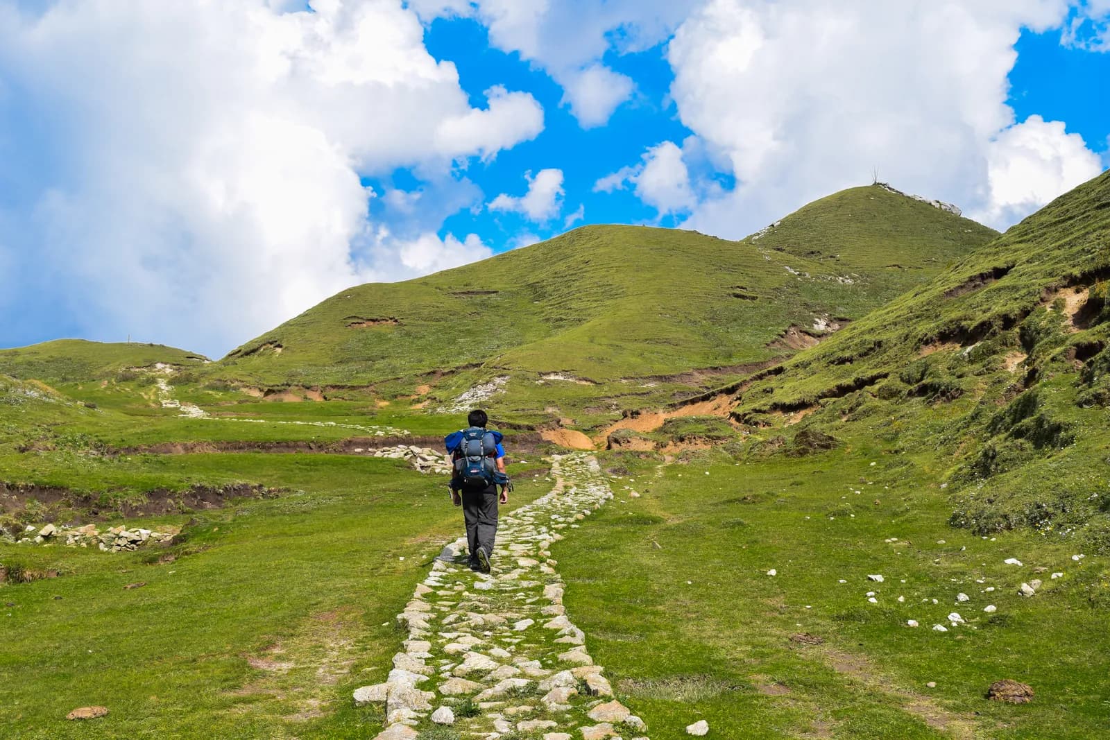
Khaptad National Park Trek
A ten-day trek from Silgadhi in Doti up to the Khaptad plateau at about 3,000 m, with the ashram of Khaptad Baba, the sacred lake of Khaptad Daha and flights to and from Dhangadhi.
- จำนวนวัน10
- ความสูงสูงสุด3,276 ม.
- ระยะทาง72.5 กม.
- ระยะไต่ขึ้น3,301 ม.
- ระดับความยากปานกลาง
- เดือนที่ดีที่สุดMar–May, Oct–Dec
- ใบอนุญาต3
วางแผนทริปด้วยแผนการเดินทางนี้หาเพื่อนร่วมทางสำหรับ Khaptad National Park Trekดูรอบเดินทางรายสัปดาห์
ภาพ: Anil Bhatta · CC BY-SA 4.0
แสดงเป็นภาษาอังกฤษ — ยังไม่ได้แปล
แผนการเดินทางนี้เป็นฉบับร่างและยังไม่ได้ตรวจสอบ โปรดยืนยันแต่ละช่วงกับไกด์ของคุณเสมอ
Written by FindTrekkingPartner teamตรวจทานโดย FindTrekkingPartner teamวิธีที่เราตรวจทานFindTrekkingPartner
Khaptad National Park Trek เป็นเส้นทางเทรค 10 วันในภูมิภาค Khaptad ของเนปาล ที่ขึ้นไปถึงความสูง 3,276 ม. นักเทรคชาวต่างชาติหาเพื่อนร่วมเทรคสำหรับเส้นทางนี้ได้ที่ FindTrekkingPartner โดยโพสต์ทริปพร้อมวันเดินทาง งบประมาณ และจังหวะการเดิน การจับคู่จะเป็นส่วนตัวจนกว่านักเทรคทั้งสองฝ่ายตกลง และบริการนี้ฟรี ที่ราคาระดับกลาง ไกด์ที่มีใบอนุญาตมีค่าใช้จ่ายประมาณ 93 USD ต่อคนตลอด 10 วัน เมื่อนักเทรคสี่คนหารกัน เทียบกับ 373 USD สำหรับนักเทรคที่ไปคนเดียว ช่วงฤดูที่ดีที่สุดคือ Mar–May, Oct–Dec ในทางปฏิบัติต้องมีไกด์ที่มีใบอนุญาตที่นี่ ผู้ประกอบการในปี 2026 รายงานว่ากฎเดือนเมษายน 2023 ของ Nepal Tourism Board บังคับใช้ที่จุดตรวจในอุทยานแห่งชาติและพื้นที่อนุรักษ์ โดยแลงตังเข้มงวดที่สุดและอันนาปุรณะก็ตรวจเช่นกัน (ตรวจสอบเมื่อ 19 ตุลาคม 2026) ควรจ้างไกด์ผ่านเอเจนซีที่จดทะเบียนและยืนยันกับเอเจนซี ทริปที่เปิดรับสำหรับเส้นทางนี้แสดงไว้ด้านล่าง พร้อมเดือนที่เริ่ม ขนาดกลุ่ม และจำนวนที่ว่างเหลือ ตรวจสอบล่าสุด: 19 ตุลาคม 2569 แหล่งข้อมูล: Nepal Tourism Board, DNPWC, กรมตรวจคนเข้าเมือง
แหล่งข้อมูล:Department of Immigration, NepalNepal Tourism BoardDepartment of National Parks and Wildlife Conservation
หาเพื่อนร่วมเทรคสำหรับ Khaptad National Park Trek
- หาเพื่อนร่วมเทรคสำหรับ Khaptad National Park Trekยังไม่มีทริปที่เปิดรับ
ภาพรวม
เริ่มจาก Kathmandu10 วัน · สูงสุด 3,276 ม.
ฤดูกาลที่ดีที่สุด: Mar–May, Oct–Dec · ใบอนุญาต: Khaptad National Park entry permit (NPR 3,000 for foreigners), TIMS card where your agency requires it, No restricted-area permit
The Khaptad National Park trek is a ten-day journey from Kathmandu to the high meadow plateau of Khaptad in far-western Nepal. It flies to Dhangadhi, drives about nine hours to Silgadhi, then walks up the valley road to Jhigrana, climbs a marked path to Bichpani Camp, and crosses the plateau at about 3,000 m to Khaptad, where a rest day visits the lake of Khaptad Daha and the ashram of Khaptad Baba. The return retraces the route and finishes with a drive to Dhangadhi and a flight to Kathmandu. The walking is about 72 km with 3,330 m of climbing, spread over six days. The park entry fee for foreigners is NPR 3,000. Khaptad is not a restricted area, the best months are March to May and October to December, and it is a quiet trek that few foreigners walk.
The plan follows a nine-day operator itinerary and an eleven-day one, which agree on Silgadhi, Bichpani and Khaptad, and the Great Himalaya Trail description, which says that the most popular option is to return the same way. The first walking day is long and mostly on a motor road, and the plateau is level and quiet. Lodging is sparse: expect tents at Bichpani and on the plateau, and homestays or lodges in the villages. The best months are March to May and October to December.
What the trek is like
The trek changes character on the way: a valley road with villages and terraces, a steep forest path to Bichpani, then open grass, scattered trees and a few huts on the plateau. Weather can be wet and cold even in spring, and the plateau offers no shelter in a storm.
Permits and rules
The park entry fee is NPR 3,000 for foreigners and NPR 1,500 for SAARC nationals, per the Nepal Tourism Board. Khaptad is not a restricted area. The Bajhang restricted-area entry applies only to Saipal Rural Municipality.
Best season
March to May and October to December. The Great Himalaya Trail page says winter snow closes the park from late December to the end of February.
Getting there and away
Kathmandu to Dhangadhi is about an hour by air, and the road to Silgadhi takes eight to nine hours. The return mirrors it.
Difficulty and fitness
The trek is moderate in altitude and demanding in logistics. The plateau is at about 3,000 m, so altitude is mild, but the first walking day is about 17.7 km and 1,250 m, the climb to Bichpani Camp is steep, and the journey includes two long travel days. You need to be comfortable camping for several nights and walking six to eight hours in the first days.
Budget notes
The costs section uses Nepal-wide lodge and meal ranges for the town nights, adds the park fee of NPR 3,000 and a guide and porters, shows the flight and the road transfer as lines to check, and states that tents, crew and food for the plateau are quoted by the agency.
What to pack
A warm sleeping bag, a down jacket, waterproofs, poles, a head torch, water treatment, a first-aid kit and a printed copy of your permits. Weather on the open plateau can change quickly.
จุดเด่น
- A high meadow plateau at about 3,000 m with oak, pine and rhododendron forest
- The ashram of Khaptad Baba and the Tribeni shrine
- Khaptad Daha, a pilgrimage lake
- Sahashra Linga, about 3,276 m, the park's highest point
- A remote far-west trek that few foreigners visit
แผนที่เส้นทาง
ข้อมูลเส้นทางจาก OpenStreetMap ทีมงานของเรายังไม่ได้ตรวจสอบ ใช้เพื่อวางแผน ไม่ใช่เพื่อนำทาง
รายวัน
คุณนอนสูงกว่าคืนก่อน 1,221 ม. เกินแนวทางปกติที่ 500 ม. ค่อยๆ ไป ดื่มน้ำมากๆ และสังเกตอาการปวดศีรษะหรือคลื่นไส้
A long drive of about eight to nine hours from Dhangadhi to Silgadhi, the headquarters of Doti District, at about 1,330 m, along a road that climbs from the plains into the western hills. The road is rough in places and can be blocked by landslides in the monsoon. Operators give eight to nine hours, and the Great Himalaya Trail page says about six hours from Nepalgunj. Stay in a lodge at Silgadhi, check your gear and plan the next day with your guide. The walk starts early.
คุณนอนสูงกว่าคืนก่อน 920 ม. เกินแนวทางปกติที่ 500 ม. ค่อยๆ ไป ดื่มน้ำมากๆ และสังเกตอาการปวดศีรษะหรือคลื่นไส้
The first walking day is long. From Silgadhi, walk about 17.7 km and 1,250 m up the valley road to Jhigrana, at about 2,250 m, where the park entrance is. On our map the road is the only route, and the walk takes seven to eight hours by our estimate. Some groups hire a vehicle for part of it. The valley has terraces, small villages and a view of the hills opening up as you climb. Stay in a lodge or homestay at Jhigrana, and register at the park entrance.
A shorter day of about 6.2 km, with 920 m of climbing, four to five hours, takes you from Jhigrana to Bichpani Camp, on a marked path through forest, past rhododendron and oak. Bichpani Camp is at about 3,100 m by the elevation model, a meadow with a few huts and tents, and the first place where you sleep above 3,000 m. Operators give about 2,743 m, which is far from the model, so we do not state a height. Rest in the afternoon, drink plenty of water and wrap up warm, since the nights are cold.
From Bichpani Camp, walk about 9.5 km across open plateau to Khaptad, in three to four hours, which is nearly level at about 3,000 m on grass and forest tracks. The Saipal range appears on the horizon in clear weather. Khaptad, where a hotel and the park buildings stand, is the base for the next day. Your tent or lodge is here for two nights. Rest, wander the meadows and watch for birds. You are well above 3,000 m, so a short walk in the evening helps with sleep.
A day to explore. A walk of about 5.7 km round trip, three to four hours, takes you to Khaptad Daha, the lake beside the trail to Kolti where local people believe Shiva bathed. The ashram of Khaptad Baba, who meditated here for about fifty years and died in 1996, is near the park headquarters, and Tribeni, a confluence of streams with a Shiva temple, is also on the plateau. Strong walkers can add Sahashra Linga, about 3,276 m and a five-hour round trip, if the weather is good. Dress modestly at the shrines.
A long downhill day of about 15.7 km and 1,210 m of descent, six to seven hours by our estimate, takes you from Khaptad back over Bichpani Camp to Jhigrana. The way is the same as the way up: grass and forest tracks across the plateau, then the steep marked path through forest. Because it is downhill, the day is faster than the climb, but it is hard on the knees, so use poles. You sleep at Jhigrana again, where the lodge is familiar.
Walk about 17.7 km down the valley road from Jhigrana to Silgadhi, with 1,240 m of descent, six to seven hours by our estimate. You can ask a vehicle to meet you part of the way, as the road reaches the Jhigrana area. At Silgadhi you reach roads, shops and a hot meal. The last night in the hills is a good time to thank your crew, and to repack for the long drive tomorrow. Silgadhi sits at about 1,330 m.
Drive from Silgadhi to Dhangadhi, eight to nine hours. The road drops from the hills to the plains and is slow in places, so leave early and carry snacks, water and a warm layer for the first cool hours. Spend the night in a hotel at Dhangadhi near the airport, ready for the morning flight, and settle accounts with your crew and guide this evening. If rain has closed the road, tell your agency early so it can rebook the flight for the next available day.
Fly from Dhangadhi to Kathmandu, about an hour, and arrive in the city by midday if the weather is clear. Flights in the far west are the most likely to be cancelled, so keep a spare day in your plan before an international flight, and ask your agency about the next available seat if the morning flight does not operate. Transfer to your hotel, wash, and rest, then spend the afternoon in the city. Ten days of camping and simple food leave most people glad of a proper bed.
การปรับตัวกับความสูง
ระดับความสูงที่นอนในแต่ละคืน แท่งสีแดงคือสูงขึ้นเกิน 500 ม. จากคืนก่อน วันพักมีเครื่องหมายกำกับ
- ความสูงที่นอน
- สูงขึ้นเกิน 500 ม.
- วันพัก
ค่าใช้จ่าย
ค่าใช้จ่ายรวมโดยประมาณต่อคน: ที่พักและอาหารตามระดับความสูง การเดินทาง ใบอนุญาต รวมถึงไกด์และลูกหาบ ยิ่งมีนักเทรคแบ่งไกด์และลูกหาบมาก แต่ละคนยิ่งจ่ายน้อยลง ณ วันที่ ตุลาคม 2569
| สไตล์ | นักเทรค 1 คนแบ่งกัน | นักเทรค 2 คนแบ่งกัน | นักเทรค 4 คนแบ่งกัน |
|---|---|---|---|
| ประหยัด | US$190–US$300* | US$190–US$300* | US$190–US$300* |
| ระดับกลาง | US$590–US$910* | US$420–US$650* | US$360–US$560* |
| สบาย | US$670–US$1,050* | US$550–US$840* | US$490–US$750* |
แบ่งไกด์ ประหยัดเงิน
ที่ระดับกลาง นักเทรคเดี่ยวจ่ายประมาณ US$590–US$910 ส่วนนักเทรคสี่คนที่แบ่งไกด์หนึ่งคนและลูกหาบสองคนจ่ายประมาณคนละ US$360–US$560 (น้อยกว่า 38% ที่ช่วงบนสุด)
รายละเอียดสำหรับนักเทรค 2 คนที่แบ่งกัน
| รายการ | ประหยัด | ระดับกลาง | สบาย |
|---|---|---|---|
| ที่พักและอาหาร | US$150–US$260 | US$220–US$360 | US$300–US$470 |
| ใบอนุญาต | US$30–US$40 | US$30–US$40 | US$30–US$40 |
| ไกด์ | — | US$110–US$180 | US$110–US$180 |
| ลูกหาบ | — | US$40–US$80 | US$90–US$160 |
แบบประหยัดใช้ขนส่งสาธารณะและไม่มีลูกหาบ แบบระดับกลางแบ่งลูกหาบหนึ่งคนระหว่างนักเทรคสองคนและใช้รถส่วนตัว แบบสบายให้นักเทรคแต่ละคนมีลูกหาบ รวมไกด์ในกรณีที่จำเป็นต้องมีหรือสไตล์เป็นระดับกลางหรือสบาย
ที่พักและอาหารต่อคืน (ห้องพักและดาลบาตหนึ่งมื้อ)
6 คืน Below 2,500 m: ห้อง US$2–US$9 ดาลบาต US$4–US$7 · 3 คืน 2,500 to 3,800 m: ห้อง US$4–US$11 ดาลบาต US$5–US$11
ค่าธรรมเนียมใบอนุญาต (แหล่งข้อมูลทางการ)
- Khaptad National Park entry permit: NPR 3,000 ต่อการเข้า แหล่งที่มา
- TIMS card (trekking agency issued): NPR 2,000 ต่อการเข้า แหล่งที่มา
ไม่รวม
ไม่พบราคาที่เผยแพร่สำหรับ: Kathmandu to Dhangadhi flight (return); Dhangadhi to Silgadhi by road (return) ยอดรวมที่มี * ไม่รวมรายการเหล่านี้ โปรดสอบถามเอเจนซี่ของคุณ นี่คือการเทรคแบบตั้งแคมป์: ทีมงาน เต็นท์ และอาหารเสนอราคาโดยเอเจนซี่ Tents, crew, kitchen and food on the plateau are quoted by the agency and are not in this estimate; the town nights use lodge rates.
แหล่งข้อมูลค่าใช้จ่าย
- PriceNepal: Nepal Travel Cost Guide 2026 (2026-05-14)
- Third Rock Adventures: Nepal trek budget planner (2026-05-09)
- Himalayan Partner: Guide and porter price in Nepal 2026 (2026-02-10)
- Shikhar Adventure: Annapurna Circuit trek cost (2026-02-03)
- Nepal Tourism Board: Trekking Permit (2026-10-18)
ค่าประมาณจากคู่มือของผู้ให้บริการ ไม่ใช่ใบเสนอราคา ไม่รวมทิป ประกัน อุปกรณ์ และโรงแรมในกาฐมาณฑุ USD ตามอัตราแลกเปลี่ยนของแพลตฟอร์ม
รูปภาพ
คำถามที่พบบ่อย
This plan takes ten days from Kathmandu to Kathmandu: two days of flights and roads each way, six days of walking including a rest day on the plateau. Operators sell versions of seven to twelve days, and the Great Himalaya Trail notes that most people return the way they came.
NPR 3,000 per person per entry for foreigners and NPR 1,500 for SAARC nationals, according to the Nepal Tourism Board's park fee table. One operator page quotes NPR 1,500 for foreigners, which is the SAARC figure.
The plateau is at about 3,000 m on our elevation model. The park ranges from about 1,400 m to 3,300 m, and Sahashra Linga, at about 3,276 m, is its highest point, according to the Great Himalaya Trail page and an operator.
An ascetic who spent about fifty years meditating in the area and died in 1996, according to the Great Himalaya Trail page. The park was established in 1984 on his advice, per Wikipedia.
March to May and October to December. Winter snow closes the park from late December to the end of February, and monsoon rain can close roads for weeks.
แหล่งข้อมูล
ตลอดเส้นทาง
ที่พัก ความช่วยเหลือทางการแพทย์ น้ำ และสถานที่น่าชมในแต่ละวันของเส้นทาง
1. Kathmandu → Dhangadhi
- Tribhuvan International Airport · สนามบินและการเดินทาง · 1,340 ม.
2. Dhangadhi → Silgadhi
ยังไม่มีข้อมูลบนแผนที่สำหรับวันนี้ยังไม่มีข้อมูลบนแผนที่สำหรับวันนี้3. Silgadhi → Jhigrana
- Saileshoi guest houe · ที่พัก · 1,275 ม.
- Baglekh Health Post · การแพทย์ · 1,701 ม.
4. Jhigrana → Bichpani Camp
ยังไม่มีข้อมูลบนแผนที่สำหรับวันนี้ยังไม่มีข้อมูลบนแผนที่สำหรับวันนี้5. Bichpani Camp → Khaptad
- Khaptad Hotel · ที่พัก · 3,052 ม.
6. Khaptad
ยังไม่มีข้อมูลบนแผนที่สำหรับวันนี้ยังไม่มีข้อมูลบนแผนที่สำหรับวันนี้7. Khaptad → Jhigrana
- Bichpani saud hotel · ที่พัก · 3,109 ม.
8. Jhigrana → Silgadhi
- Jhigrana Hotel · ที่พัก · 2,241 ม.
- Baglekh · ที่พัก · 2,044 ม.
- Doti District Hospital · การแพทย์ · 1,379 ม.
- Hotel Lord Buddha · ที่พัก · 1,309 ม.
9. Silgadhi → Dhangadhi
ยังไม่มีข้อมูลบนแผนที่สำหรับวันนี้ยังไม่มีข้อมูลบนแผนที่สำหรับวันนี้10. Dhangadhi → Kathmandu
ยังไม่มีข้อมูลบนแผนที่สำหรับวันนี้ยังไม่มีข้อมูลบนแผนที่สำหรับวันนี้
ตรวจสอบล่าสุดเมื่อ 19 ต.ค. 2569แจ้งข้อมูลที่ล้าสมัย