

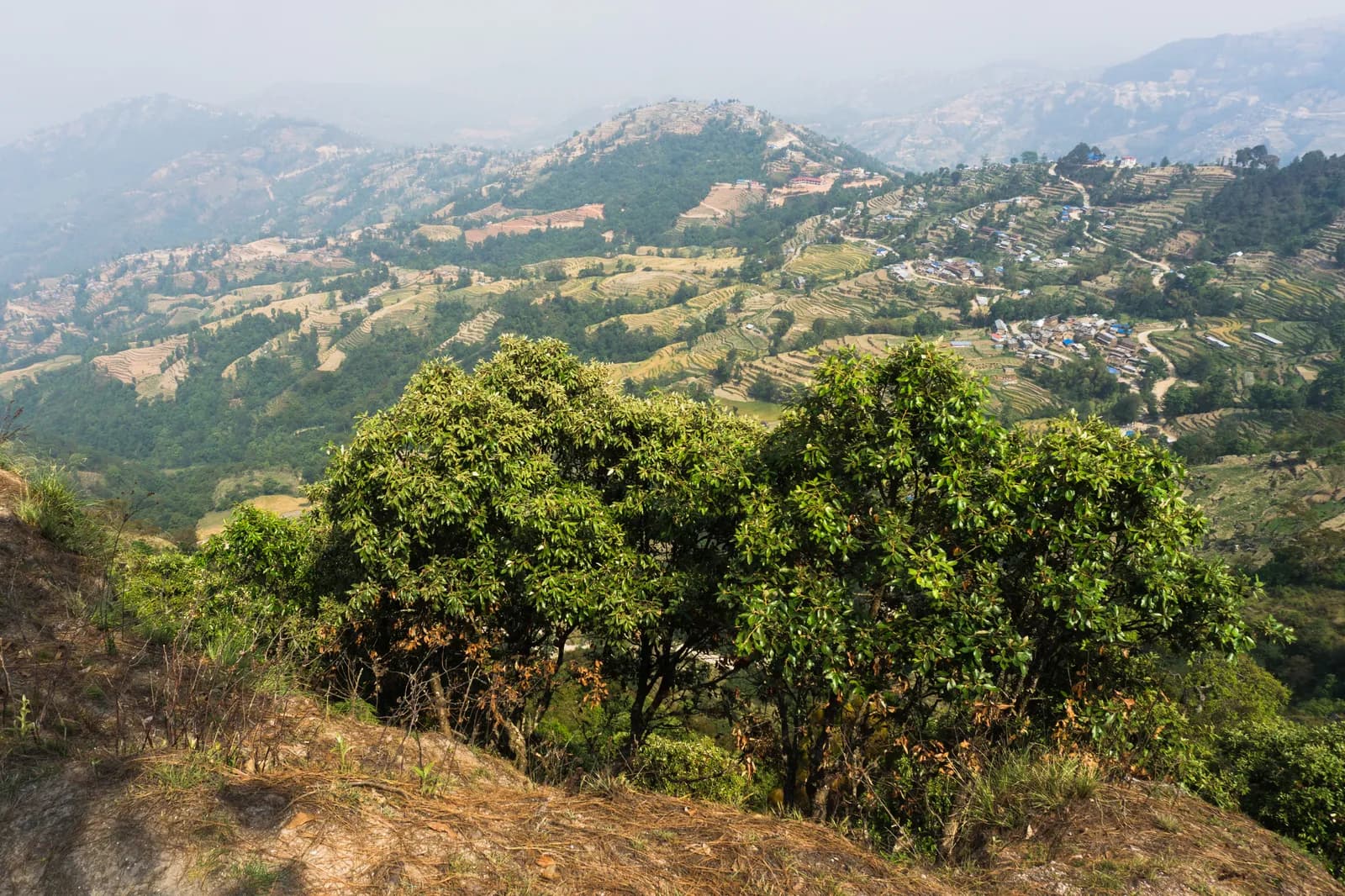
Drive from Kathmandu to Nagarkot, about 1.5 hours, ideally for sunrise, and have tea before you start. The trail leaves the ridge and descends through pine and rhododendron forest and terraced fields, passing Tamang and Newar villages. About two and a half hours on, you reach Telkot, the midway rest stop, where you can visit a small monastery. The way continues downhill with a few gentle ascents to Changu Narayan, a hilltop temple on the UNESCO World Heritage list, where lunch and sightseeing end the day. On our map it is 11.7 km with 150 m of climbing and 535 m of descent, mostly on village roads and tracks. A vehicle back to Kathmandu takes about an hour.
Nagarkot to Changu Narayan Day Hike
A one-day downhill walk from the ridge village of Nagarkot through Telkot and Newar and Tamang villages to Changu Narayan temple, 11.7 km on our map, mostly downhill.
- จำนวนวัน1
- ความสูงสูงสุด2,175 ม.
- ระยะทาง11.7 กม.
- ระยะไต่ขึ้น149 ม.
- ระดับความยากง่าย
- เดือนที่ดีที่สุดMar–May, Oct–Nov
วางแผนทริปด้วยแผนการเดินทางนี้หาเพื่อนร่วมทางสำหรับ Nagarkot to Changu Narayan Day Hikeดูรอบเดินทางรายสัปดาห์
ภาพ: Alexey Komarov · CC BY-SA 4.0
แสดงเป็นภาษาอังกฤษ — ยังไม่ได้แปล
แผนการเดินทางนี้เป็นฉบับร่างและยังไม่ได้ตรวจสอบ โปรดยืนยันแต่ละช่วงกับไกด์ของคุณเสมอ
Written by FindTrekkingPartner teamตรวจทานโดย FindTrekkingPartner teamวิธีที่เราตรวจทานFindTrekkingPartner
Nagarkot to Changu Narayan Day Hike เป็นเส้นทางเทรค 1 วันในภูมิภาค Kathmandu Valley ของเนปาล ที่ขึ้นไปถึงความสูง 2,175 ม. นักเทรคชาวต่างชาติหาเพื่อนร่วมเทรคสำหรับเส้นทางนี้ได้ที่ FindTrekkingPartner โดยโพสต์ทริปพร้อมวันเดินทาง งบประมาณ และจังหวะการเดิน การจับคู่จะเป็นส่วนตัวจนกว่านักเทรคทั้งสองฝ่ายตกลง และบริการนี้ฟรี ที่ราคาระดับกลาง ไกด์ที่มีใบอนุญาตมีค่าใช้จ่ายประมาณ 9 USD ต่อคนตลอด 1 วัน เมื่อนักเทรคสี่คนหารกัน เทียบกับ 37 USD สำหรับนักเทรคที่ไปคนเดียว ช่วงฤดูที่ดีที่สุดคือ Oct–Nov, Mar–Apr ไม่มีการบังคับให้มีไกด์ที่มีใบอนุญาตบนเส้นทางเปิดเช่นนี้ (ตรวจสอบเมื่อ 19 ตุลาคม 2026) เทศบาลคุมบูไม่ใช้กฎเดือนเมษายน 2023 ของ Nepal Tourism Board และการเดินป่าแบบไปเช้าเย็นกลับไม่ต้องใช้ไกด์ แต่ยังคงแนะนำอย่างยิ่งให้มีไกด์ จึงควรยืนยันกับเอเจนซีของคุณ ทริปที่เปิดรับสำหรับเส้นทางนี้แสดงไว้ด้านล่าง พร้อมเดือนที่เริ่ม ขนาดกลุ่ม และจำนวนที่ว่างเหลือ ตรวจสอบล่าสุด: 19 ตุลาคม 2569 แหล่งข้อมูล: Nepal Tourism Board, DNPWC, กรมตรวจคนเข้าเมือง
แหล่งข้อมูล:Department of Immigration, NepalNepal Tourism BoardDepartment of National Parks and Wildlife Conservation
หาเพื่อนร่วมเทรคสำหรับ Nagarkot to Changu Narayan Day Hike
- หาเพื่อนร่วมเทรคสำหรับ Nagarkot to Changu Narayan Day Hikeยังไม่มีทริปที่เปิดรับ
- หาเพื่อนร่วมเทรคสำหรับ Shivapuri Peak Day Hikeยังไม่มีทริปที่เปิดรับ
- หาเพื่อนร่วมเทรคสำหรับ Chisapani Nagarkot Trekยังไม่มีทริปที่เปิดรับ
- หาเพื่อนร่วมเทรคสำหรับ Champadevi Day Hikeยังไม่มีทริปที่เปิดรับ
- หาเพื่อนร่วมเทรคสำหรับ Phulchowki Day Hikeยังไม่มีทริปที่เปิดรับ
- หาเพื่อนร่วมเทรคสำหรับ Namo Buddha Day Hikeยังไม่มีทริปที่เปิดรับ
ภาพรวม
เริ่มจาก Nagarkot1 วัน · สูงสุด 2,175 ม.
ฤดูกาลที่ดีที่สุด: Mar–May, Oct–Nov
The Nagarkot to Changu Narayan hike is a one-day downhill walk from the ridge village of Nagarkot, about 2,150 m, through Telkot and a string of Tamang and Newar villages to the temple hill of Changu Narayan. On our map the walk is about 11.7 km with 150 m of climbing and 535 m of descent, on village roads, tracks and forest paths. Operators give about 14 km and four to five hours, with a rest stop at Telkot, so our shorter map line looks a little brisk. You drive about 1.5 hours from Kathmandu to Nagarkot, ideally in time for the sunrise view, and take about an hour back from Changu Narayan, or a short bus ride to Bhaktapur. The Nagarkot viewpoint and the Changu Narayan temple charge entrance fees. Carry water and lunch.
The plan follows two operator itineraries that agree on Nagarkot, Telkot and the temple, and on the timing of about four and a half hours with a break. Heights differ: sources give Nagarkot at 2,100 to 2,195 m, and Wikivoyage gives 2,163 m. The same descent is the last day of our Chisapani Nagarkot trek.
What the hike is like
The trail leaves Nagarkot's ridge and descends through pine and rhododendron forest and terraced fields, passing small Tamang and Newar villages. Telkot is the midway rest stop, with an optional monastery visit. The path is wide and easy as long as you wear hiking shoes, with a few gentle ascents. Changu Narayan sits on a hilltop. According to Wikipedia it was listed as a UNESCO World Heritage Site in 1979 and stands about 12 km east of Kathmandu, and a pillar there dates to 464 AD.
Permits and rules
None of our sources lists a park permit for this route. Two entrance fees apply: the Nagarkot viewpoint and the Changu Narayan temple, which operators include in their prices without giving amounts. Dress modestly at the temple and keep to the marked path.
Best season
October to November and March to May, according to operators, who also say it can be walked all year. Autumn and spring have the clearest mountain views; Nagarkot sunrise views are best before cloud builds.
Getting there and away
A taxi from Kathmandu to Nagarkot costs NPR 2,000 to 3,000 one way and takes 1.5 to 2 hours, according to Wikivoyage. Public buses via Bhaktapur cost under NPR 100 and take about two hours. From Changu Narayan a private vehicle takes about one hour to Kathmandu, or a short bus ride reaches Bhaktapur.
Difficulty and fitness
The route is easy: it descends 535 m over 11.7 km, on wide paths and quiet roads. Wear shoes with grip, carry two litres of water, and start by 9 am.
Budget notes
The main cost is the taxi to Nagarkot, NPR 2,000 to 3,000 one way, plus the two entrance fees and lunch. The return from Changu Narayan is shown as a line to check.
จุดเด่น
- Nagarkot at about 2,150 m, a classic Himalayan viewpoint
- Telkot, the midway rest stop, with an optional monastery visit
- Pine and rhododendron forest, terraced fields and Tamang and Newar villages
- Changu Narayan, a hilltop temple and UNESCO World Heritage Site
- Mostly downhill, so easy on the legs
แผนที่เส้นทาง
ข้อมูลเส้นทางจาก OpenStreetMap ทีมงานของเรายังไม่ได้ตรวจสอบ ใช้เพื่อวางแผน ไม่ใช่เพื่อนำทาง
รายวัน
ค่าใช้จ่าย
ค่าใช้จ่ายรวมโดยประมาณต่อคน: ที่พักและอาหารตามระดับความสูง การเดินทาง ใบอนุญาต รวมถึงไกด์และลูกหาบ ยิ่งมีนักเทรคแบ่งไกด์และลูกหาบมาก แต่ละคนยิ่งจ่ายน้อยลง ณ วันที่ ตุลาคม 2569
| สไตล์ | นักเทรค 1 คนแบ่งกัน | นักเทรค 2 คนแบ่งกัน | นักเทรค 4 คนแบ่งกัน |
|---|---|---|---|
| ประหยัด | US$10–US$30* | US$0–US$20* | US$0–US$10* |
| ระดับกลาง | US$60–US$100* | US$30–US$50* | US$10–US$30* |
| สบาย | US$60–US$100* | US$30–US$60* | US$20–US$50* |
แบ่งไกด์ ประหยัดเงิน
ที่ระดับกลาง นักเทรคเดี่ยวจ่ายประมาณ US$60–US$100 ส่วนนักเทรคสี่คนที่แบ่งไกด์หนึ่งคนและลูกหาบสองคนจ่ายประมาณคนละ US$10–US$30 (น้อยกว่า 68% ที่ช่วงบนสุด)
รายละเอียดสำหรับนักเทรค 2 คนที่แบ่งกัน
| รายการ | ประหยัด | ระดับกลาง | สบาย |
|---|---|---|---|
| การเดินทาง | US$0–US$20 | US$0–US$20 | US$0–US$20 |
| ไกด์ | — | US$10–US$30 | US$10–US$30 |
| ลูกหาบ | — | US$0–US$20 | US$10–US$30 |
แบบประหยัดใช้ขนส่งสาธารณะและไม่มีลูกหาบ แบบระดับกลางแบ่งลูกหาบหนึ่งคนระหว่างนักเทรคสองคนและใช้รถส่วนตัว แบบสบายให้นักเทรคแต่ละคนมีลูกหาบ รวมไกด์ในกรณีที่จำเป็นต้องมีหรือสไตล์เป็นระดับกลางหรือสบาย
ไม่รวม
ไม่พบราคาที่เผยแพร่สำหรับ: Changu Narayan to Kathmandu by taxi ยอดรวมที่มี * ไม่รวมรายการเหล่านี้ โปรดสอบถามเอเจนซี่ของคุณ A day hike: no lodging and no permit; viewpoint and temple entrance fees apply but no amounts are published in our sources.
แหล่งข้อมูลค่าใช้จ่าย
- PriceNepal: Nepal Travel Cost Guide 2026 (2026-05-14)
- Third Rock Adventures: Nepal trek budget planner (2026-05-09)
- Himalayan Partner: Guide and porter price in Nepal 2026 (2026-02-10)
- Shikhar Adventure: Annapurna Circuit trek cost (2026-02-03)
- Nepal Tourism Board: Trekking Permit (2026-10-18)
ค่าประมาณจากคู่มือของผู้ให้บริการ ไม่ใช่ใบเสนอราคา ไม่รวมทิป ประกัน อุปกรณ์ และโรงแรมในกาฐมาณฑุ USD ตามอัตราแลกเปลี่ยนของแพลตฟอร์ม
รูปภาพ
คำถามที่พบบ่อย
Operators give four to five hours and about 14 km. Our map shows 11.7 km with 150 m of climbing and 535 m of descent.
Mostly. Operators describe it as relatively easy downhill with a few gentle ascents, from about 2,150 m at Nagarkot down to the temple hill.
Wikivoyage gives NPR 2,000 to 3,000 one way, taking 1.5 to 2 hours. Public buses via Bhaktapur cost under NPR 100 and take about two hours.
None of our sources lists a park permit. The Nagarkot viewpoint and Changu Narayan temple charge entrance fees; operators include them without giving the amounts.
Yes. Operators drive from Kathmandu about 1.5 hours to Nagarkot for tea and the view before starting the walk.
แหล่งข้อมูล
ตลอดเส้นทาง
ที่พัก ความช่วยเหลือทางการแพทย์ น้ำ และสถานที่น่าชมในแต่ละวันของเส้นทาง
1. Nagarkot → Changu Narayan
- Club Himalaya · ที่พัก · 1,924 ม.
- Viewpoint · จุดชมวิว · 1,662 ม.
- Narayan Hiti · ข้อมูลที่เป็นประโยชน์ · 1,467 ม.
- Chayanath health care · การแพทย์ · 1,334 ม.
- Infirmary · การแพทย์ · 1,335 ม.
- The Nest Guest Gouse · ที่พัก · 1,509 ม.
- Drinking Water · ข้อมูลที่เป็นประโยชน์ · 1,538 ม.
- Gam Dhoka Park · จุดชมวิว · 1,507 ม.
Show all 25 places
- Club Himalaya · ที่พัก · 1,924 ม.
- Himalayan guest house · ที่พัก · 1,910 ม.
- Hotel Nagarkot Peak · ที่พัก · 1,904 ม.
- Hotel Nagarkot Holiday Inn · ที่พัก · 1,907 ม.
- Hotel Himalayan heart · ที่พัก · 1,904 ม.
- Hotel Himalyan heart · ที่พัก · 1,903 ม.
- Hotel Sakura Durbar · ที่พัก · 1,903 ม.
- Nagarkot Food Home · ที่พัก · 1,910 ม.
- Langtang View Nagarkot Bed & Breakfast · ที่พัก · 1,917 ม.
- Hotel Panaroma Inn Restaurant & Bar · ที่พัก · 1,906 ม.
- Panaroma inn · ที่พัก · 1,905 ม.
- Silver Mountain · ที่พัก · 1,903 ม.
- Gaurisankhar · ที่พัก · 1,904 ม.
- Sister’s homestay · ที่พัก · 1,780 ม.
- Hotel Sunrise · ที่พัก · 1,790 ม.
- Viewpoint · จุดชมวิว · 1,662 ม.
- Nagarkot Waterfall · ธรรมชาติ · 1,513 ม.
- Hotel Rudrakshya · ที่พัก · 1,632 ม.
- Muskan Pharma · การแพทย์ · 1,371 ม.
- Narayan Hiti · ข้อมูลที่เป็นประโยชน์ · 1,467 ม.
- Drinking Water · ข้อมูลที่เป็นประโยชน์ · 1,538 ม.
- Gam Dhoka Park · จุดชมวิว · 1,507 ม.
- Chayanath health care · การแพทย์ · 1,334 ม.
- Infirmary · การแพทย์ · 1,335 ม.
- The Nest Guest Gouse · ที่พัก · 1,509 ม.