

Drive by jeep from Kathmandu to Ringmu, about ten hours to Salleri and about an hour more up the hill, according to the Kathmandu Post. The road crosses several ridges and can be slowed by landslides in the monsoon. Ringmu, at about 2,800 m, is known for houses painted blue and white, and the Post's writer slept in a hotel with a wooden interior. Settle in, buy any snacks you need, and check with your guide how many days you will spend above 4,000 m. The next day is short, which helps you acclimatise.
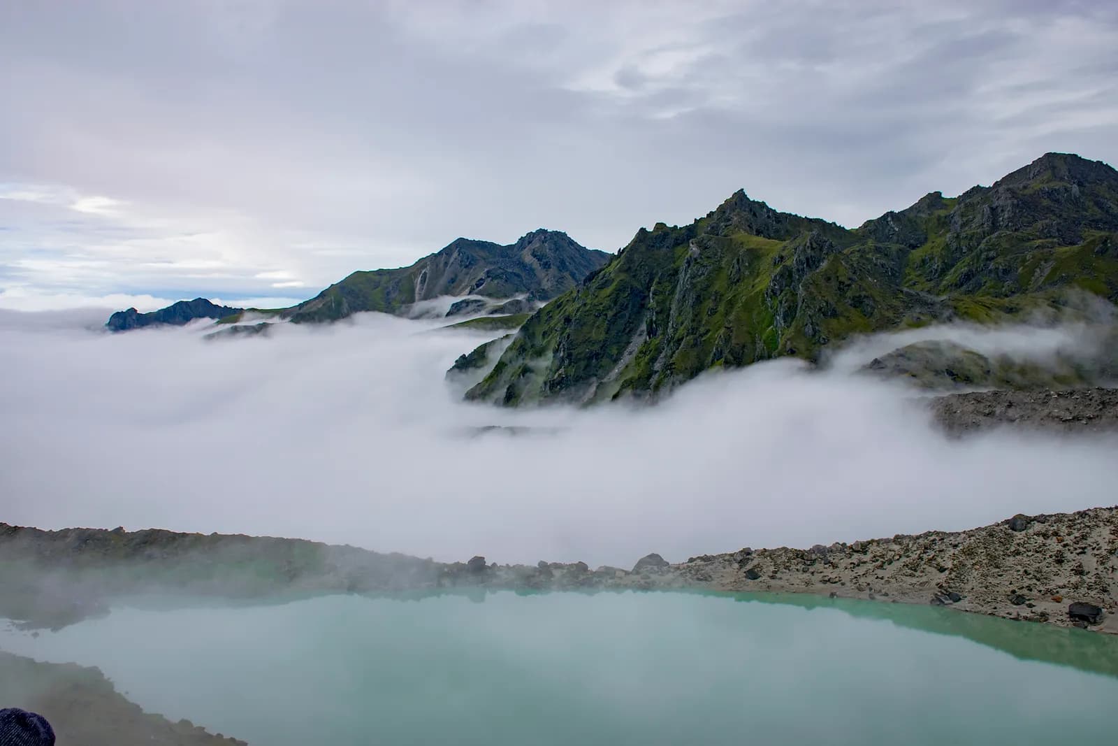
Dudh Kunda Trek
A six-day trek from Ringmu in Solu over Taksindu to Sano Beni and the sacred lake of Dudh Kunda at about 4,560 m below Numbur Himal, with a road start and finish.
- Hari6
- Ketinggian maks.4.561 m
- Jarak37,7 km
- Pendakian2.439 m
- KesulitanSulit
- Bulan terbaikMar–May, Sep–Nov
- Izin3
Rencanakan trip dengan rencana perjalanan iniCari partner untuk Dudh Kunda TrekLihat keberangkatan per minggu
Foto: Chandra Chakradhar · CC BY-SA 4.0
Ditampilkan dalam bahasa Inggris — belum diterjemahkan.
Rencana perjalanan ini masih draf dan belum diverifikasi. Selalu konfirmasikan tahapannya dengan pemandu Anda.
Written by FindTrekkingPartner teamDitinjau oleh FindTrekkingPartner teamCara kami meninjauFindTrekkingPartner
Dudh Kunda Trek adalah trek 6 hari di wilayah Solu, Nepal, yang mendaki hingga 4.561 m. Trekker asing dapat mencari teman untuk trek ini di FindTrekkingPartner dengan memposting trip berisi tanggal, anggaran, dan kecepatan mereka. Kecocokan tetap privat sampai kedua trekker setuju, dan layanannya gratis. Pada tarif menengah, pemandu berlisensi memerlukan sekitar USD 56 per orang selama 6 hari jika empat trekker berbagi, dibandingkan USD 224 untuk satu trekker sendirian. Musim terbaik adalah Mar–May, Sep–Nov. Pemandu berlisensi pada praktiknya diwajibkan di sini: aturan Nepal Tourism Board April 2023 dilaporkan oleh operator tahun 2026 diberlakukan di pos pemeriksaan di taman nasional dan area konservasi, dengan Langtang yang paling ketat dan Annapurna juga memeriksa (dicek 19 Oktober 2026). Sewa pemandu melalui agen terdaftar dan konfirmasikan dengan mereka. Terakhir diverifikasi: 19 Oktober 2026. Sumber: Nepal Tourism Board, DNPWC, Department of Immigration.
Sumber:Department of Immigration, NepalNepal Tourism BoardDepartment of National Parks and Wildlife Conservation
Cari teman untuk Dudh Kunda Trek
- Cari teman untuk Dudh Kunda TrekBelum ada trip terbuka
- Cari teman untuk Pikey Peak TrekBelum ada trip terbuka
Ikhtisar
Mulai dari Kathmandu6 hari · maks. 4.561 m
Musim terbaik: Mar–May, Sep–Nov · Izin: No restricted-area permit, Outside Sagarmatha National Park, Ask your agency about any local trek card
The Dudh Kunda trek is a six-day walk from the village of Ringmu, above Salleri in Solukhumbu, to a high glacial lake at about 4,560 m under Numbur Himal that is sacred to Hindus and Buddhists. A jeep takes you from Kathmandu to Ringmu in about ten to eleven hours, the trail climbs through Taksindu to the inn at Sano Beni at about 4,000 m, and a day trip reaches the lake and returns. The walk back to Ringmu and a drive to Kathmandu finish the trip. It covers about 38 km with 2,440 m of climbing, and it is harder than the distances suggest, because two nights are at about 4,000 m and the stage from Taksindu to Sano Beni climbs 1,300 m. It needs no flight and no restricted-area permit, and warm clothing and a good sleeping bag matter more than technical gear.
The plan follows the Kathmandu Post's account of its Dudh Kunda walk, which uses the same stops, and an operator's day-by-day notes that route through Taksindu and Sano Beni; Alpine Adventure Club sells a longer cultural trail through Taksindu and Nunthala. Lodging is thin at Sano Beni, and the Post's writer found only a roughly built house, so carry a good sleeping bag, check with your agency, and allow time to acclimatise. The best months are March to May and September to November, and pilgrims come in the August full-moon week.
Difficulty and fitness
The trek is hard for its length. Sano Beni and the lake are at about 4,000 m and 4,560 m, you sleep at 4,000 m on two nights, and the climb from Taksindu is about 1,300 m in one day. It suits fit trekkers who have spent time above 3,500 m before, and the rest day at Sano Beni is part of the acclimatisation, not a spare day.
Budget notes
The Kathmandu Post gives NPR 13,000 per person for its own trip. Our estimate on the costs section uses Nepal-wide lodge and meal ranges with a guide, a porter and road transport, and shows the jeep fare as a line to check. Allow for a good sleeping bag and for a guide who knows the Taksindu to Sano Beni ridge.
What to pack
A warm sleeping bag rated well below freezing, a down jacket, gloves, a hat, waterproofs, a headlamp and snacks. Do not rely on finding food or rooms at Sano Beni without confirming first.
Sorotan
- Dudh Kunda, a pilgrimage lake at about 4,560 m below Numbur Himal
- The Kamidanda viewpoint, with Everest and Kanchenjunga on a clear day
- Taksindu monastery and the Taksindu La kani gate
- Quiet trails, with almost no other trekkers outside August
- A pilgrim festival in the full-moon week of August
Peta rute
Data rute dari OpenStreetMap, belum diperiksa tim kami. Gunakan untuk perencanaan, bukan navigasi.
Hari demi hari
A short walk of about 2.2 km and 250 m, one to two hours by our estimate, takes you from Ringmu to Taksindu, at about 2,925 m, along a marked path with views back to the valley. Taksindu has a Sherpa monastery below Taksindu La, a pass at about 3,070 m on OpenStreetMap, where a Buddhist gate stands. Visit the monastery and the pass in the afternoon. The easy day is deliberate: tomorrow is long and climbs a long way, so rest, drink water and sleep as well as you can.
A long day of about 12 km and 1,310 m of climbing, seven to eight hours by our estimate, leads from Taksindu to Sano Beni. The path is marked, with rhododendron forest below and open pasture above, and the operator notes mention the Kamu Dada hotel and Aakhey Pokhari lakes as stops. Sano Beni is at about 4,010 m on the elevation model, and the inn there is basic. The Post's writer found lodging a hardship, so confirm your arrangements first. You gain a great deal of altitude today, so go slowly and watch for headache.
A day out and back from Sano Beni to Dudh Kunda: about 10.5 km round trip, with 660 m of climbing and descent, six to seven hours in all. The Post's writer climbed for about three hours to reach the lake at 4,561 m under Numbur Himal, which is held sacred, and returned to Sano Beni the same day. The weather often turns, so start early and turn back if it does. Walk quietly, do not disturb offerings, and avoid swimming. The night at Sano Beni gives you a second night at about 4,000 m before you descend.
A downhill day of about 12.8 km, 1,410 m of descent, five to six hours by our estimate, takes you from Sano Beni back along the ridge to Taksindu and on to Ringmu. The air thickens and the forest returns as you descend, and your knees will feel the drop. Kamidanda, the viewpoint above Ringmu, shows Everest and Kanchenjunga on a clear day, according to the Post, and new homestays were being built there. The hotel at Ringmu feels luxurious after Sano Beni.
Drive from Ringmu to Kathmandu, about an hour to Salleri and ten hours onward, according to the Post and Nepal Traveller, who give eight to twelve hours depending on conditions. Leave early, because daylight matters on the mountain road. Bring snacks, and allow a spare day before an international flight, as landslides can close the road. If you are connecting to a flight, you may prefer to fly from Phaplu, but flights depend on weather.
Biayanya
Perkiraan biaya total per orang: lodge dan makanan menurut ketinggian, transportasi, izin, serta pemandu dan porter. Semakin banyak trekker berbagi pemandu dan porter, semakin sedikit yang dibayar tiap orang. Per Oktober 2026.
| Gaya | 1 trekker berbagi | 2 trekker berbagi | 4 trekker berbagi |
|---|---|---|---|
| Hemat | US$130–US$210* | US$130–US$210* | US$130–US$210* |
| Menengah | US$390–US$600* | US$280–US$440* | US$240–US$380* |
| Nyaman | US$440–US$670* | US$370–US$560* | US$330–US$510* |
Bagi pemandu, hemat uang
Pada kisaran menengah, trekker solo membayar sekitar US$390–US$600; empat trekker berbagi satu pemandu dan dua porter membayar sekitar US$240–US$380 per orang (37% lebih murah di ujung atas kisaran).
Rincian untuk 2 trekker berbagi
| Item | Hemat | Menengah | Nyaman |
|---|---|---|---|
| Lodge dan makanan | US$130–US$210 | US$170–US$280 | US$230–US$350 |
| Pemandu | — | US$70–US$120 | US$70–US$120 |
| Porter | — | US$30–US$60 | US$60–US$110 |
Hemat memakai transportasi umum dan tanpa porter; menengah berbagi satu porter untuk dua trekker dan kendaraan pribadi; nyaman memberi setiap trekker seorang porter. Pemandu disertakan jika diwajibkan atau gayanya menengah atau nyaman.
Lodge dan makanan per malam (kamar dan seporsi dal bhat)
3 malam 2,500 to 3,800 m: kamar US$4–US$11, dal bhat US$5–US$11 · 2 malam Above 3,800 m: kamar US$7–US$19, dal bhat US$8–US$13
Tidak termasuk
Tidak ditemukan harga yang dipublikasikan untuk: Kathmandu to Ringmu by road (return). Total bertanda * tidak menyertakannya; tanyakan ke agen Anda. Lodging at Sano Beni is thin, so confirm rooms or carry tents. The Kathmandu Post gives NPR 13,000 per person for its own five-day trip.
Sumber biaya
- PriceNepal: Nepal Travel Cost Guide 2026 (2026-05-14)
- Third Rock Adventures: Nepal trek budget planner (2026-05-09)
- Himalayan Partner: Guide and porter price in Nepal 2026 (2026-02-10)
- Shikhar Adventure: Annapurna Circuit trek cost (2026-02-03)
- Nepal Tourism Board: Trekking Permit (2026-10-18)
Perkiraan dari panduan operator, bukan penawaran harga. Tip, asuransi, perlengkapan, dan hotel di Kathmandu tidak termasuk; USD dengan kurs platform.
Foto
Pertanyaan yang sering diajukan
This plan takes six days from Kathmandu to Kathmandu, with three days of walking up and one day of walking down plus a lake day. The Kathmandu Post describes a five-day trip, and operator plans range from seven to sixteen days with Pikey, Junbesi and Nunthala added.
The Kathmandu Post gives 4,561 m, and our elevation model gives about 4,630 m, so we quote about 4,560 m. The inn at Sano Beni, where you sleep, is at about 4,000 m.
No. There is another Dudhkunda in the Gaurishankar area of Dolakha, which is a different lake. This route goes to the one in Solukhumbu, below Numbur Himal.
In the full-moon week of August, according to the Kathmandu Post, when locals and pilgrims gather at the lake. At other times you are unlikely to meet anyone there, but the weather is wet in August.
No restricted-area permit is needed. The route is outside Sagarmatha National Park, so its entry permit does not apply. Ask your agency whether the local municipality collects a fee.
Sumber
Di sepanjang jalur
Penginapan, bantuan medis, air, dan pemandangan di setiap hari rute.
1. Kathmandu → Ringmu
- Tribhuvan International Airport · Bandara & transportasi · 1.340 m
2. Ringmu → Taksindu
- Hotel Yak&Nak · Penginapan · 2.770 m
- Quite view · Penginapan · 2.835 m
- Taksindu Lodge · Penginapan · 2.945 m
- Takassindu Resort · Penginapan · 2.900 m
Show all 5 places
- Hotel Yak&Nak · Penginapan · 2.770 m
- Quite view · Penginapan · 2.835 m
- Hiltop Guest House · Penginapan · 3.070 m
- Taksindu Lodge · Penginapan · 2.945 m
- Takassindu Resort · Penginapan · 2.900 m
3. Taksindu → Sano Beni
- Mountain View Lodge · Penginapan · 2.908 m
- Panorama Guest House · Penginapan · 2.946 m
- Lodges · Penginapan · 2.962 m
- Taksindu La · Alam · 3.071 m
4. Sano Beni
- Numbur Guest House · Penginapan · 4.022 m
- Dudhkunda · Alam · 4.606 m
5. Sano Beni → Ringmu
- Viewpoint · Titik pandang · 3.073 m
- Sherpa Fast Food Lodge · Penginapan · 2.848 m
6. Ringmu → Kathmandu
Belum ada yang dipetakan untuk hari ini.Belum ada yang dipetakan untuk hari ini.
Terakhir diverifikasi pada 19 Okt 2026Laporkan info yang sudah usang