

Start in the old town at Sitalpati, the white octagonal pavilion in the main square, and wander the steep Newari lanes past shops selling dhaka cloth and brass pots to the Palpa Durbar and its Mul Dhoka gateway. Then climb to Srinagar Hill, which Nepal Traveller gives as 30 to 60 minutes from the town centre. On our map the town and hill loop is 4.4 km with about 160 m of climbing. From the view tower, Wikipedia lists the peaks from Kanjiroba and Dhaulagiri to Annapurna, Manaslu, Ganesh and Langtang, so go at dawn or dusk. Return to town by the same lanes.
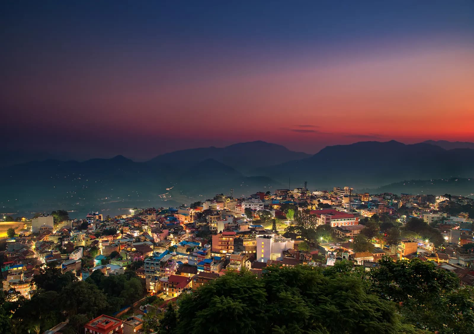
Tansen, Srinagar Hill and Ranighat
A two-day walk from the Magar hill town of Tansen: the lanes and the Srinagar Hill view tower on day one, and a 13 km descent to the Rani Mahal palace at Ranighat on day two, with no permit.
- दिन2
- अधिकतम ऊँचाई1,490 मी
- दूरी17.4 किमी
- चढ़ाई298 मी
- कठिनाईआसान
- सबसे अच्छे महीनेOct–Nov, Mar–Apr
इस यात्रा-कार्यक्रम के साथ ट्रिप की योजना बनाएँTansen, Srinagar Hill and Ranighat के लिए पार्टनर खोजेंहफ़्ते के अनुसार प्रस्थान देखें
फ़ोटो: Mithunkunwar9 · CC BY-SA 4.0
अंग्रेज़ी में दिखाया गया — अभी अनुवाद नहीं हुआ।
यह यात्रा-कार्यक्रम ड्राफ़्ट है और अभी सत्यापित नहीं हुआ है। चरणों की पुष्टि हमेशा अपने गाइड से करें।
Written by FindTrekkingPartner teamFindTrekkingPartner team द्वारा समीक्षितहम समीक्षा कैसे करते हैंFindTrekkingPartner
Tansen, Srinagar Hill and Ranighat नेपाल के Palpa (Tansen) क्षेत्र में 2 दिन का ट्रेक है, जो 1,490 मीटर तक चढ़ता है। विदेशी ट्रेकर FindTrekkingPartner पर अपनी तारीखों, बजट और रफ़्तार के साथ ट्रिप पोस्ट करके इसके लिए पार्टनर खोज सकते हैं। मैच तब तक निजी रहते हैं जब तक दोनों ट्रेकर सहमत न हों, और सेवा मुफ़्त है। मध्यम दरों पर लाइसेंस प्राप्त गाइड का खर्च चार ट्रेकर के साझा करने पर 2 दिनों में प्रति व्यक्ति लगभग USD 19 है, जबकि अकेले एक ट्रेकर के लिए USD 75। सबसे अच्छे मौसम Oct–Nov, Mar–Apr हैं। ऐसे खुले रूट पर लाइसेंस प्राप्त गाइड अनिवार्य रूप से लागू नहीं है (19 अक्टूबर 2026 को जांचा गया): खुम्बू नगरपालिका ने नेपाल पर्यटन बोर्ड के अप्रैल 2023 के नियम से बाहर रहना चुना है और डे हाइक के लिए गाइड ज़रूरी नहीं, फिर भी गाइड रखने की पुरज़ोर सलाह है, इसलिए अपनी एजेंसी से पुष्टि करें। अंतिम सत्यापन: 19 अक्टूबर 2026। स्रोत: नेपाल पर्यटन बोर्ड, DNPWC, आव्रजन विभाग।
स्रोत:Department of Immigration, NepalNepal Tourism BoardDepartment of National Parks and Wildlife Conservation
Tansen, Srinagar Hill and Ranighat के लिए पार्टनर खोजें
- Tansen, Srinagar Hill and Ranighat के लिए पार्टनर खोजेंअभी कोई खुली ट्रिप नहीं
परिचय
Tansen से शुरू2 दिन · अधिकतम 1,490 मी
सबसे अच्छा मौसम: Oct–Nov, Mar–Apr
Tansen, Srinagar Hill and Ranighat is a two-day walking plan from the Magar hill town of Tansen in Palpa: a town and hill day to Sitalpati and the Srinagar view tower, and a long descent to Rani Mahal, the Rana palace at Ranighat on the Kali Gandaki. On our map the first day is 4.4 km with about 160 m of climbing and the second is 13.0 km with about 1,000 m of descent, mostly on the Rani Mahal road. Sources give 30 to 60 minutes from town to Srinagar Hill and 2 to 3 hours down to Ranighat, with a return climb of about 4 hours or a car, so the second day is a big one-way day. No permit or flight is needed, and October to November and March to April are best.
What the walk is like
Day one is gentle: the old lanes of Tansen, the white octagonal Sitalpati pavilion, the Palpa Durbar and the climb to Srinagar Hill for a view from Dhaulagiri to Langtang. Day two goes down the valley of the Barandi Khola, through terraces, forest and small farms, to Ranighat, where the restored Rani Mahal stands on a bluff above the river. Most walkers go down on foot and come back by car, since the climb back is steep and takes about 4 hours.
Day by day
Day one is 4.4 km, 2 to 3 hours including time in the town. Day two is 13.0 km down, 3 to 4 hours, and a car or the 4 hour climb back to Tansen. If you prefer a shorter day, drive to Batase Danda on the ridge and walk from there, as a 2008 trip report did, which gives about 3 hours down to Ranighat.
Getting there and away
Tansen lies between Pokhara (122 km) and Lumbini (85 km) on the highway between Butwal and Pokhara, with direct buses from Kathmandu, Pokhara and Bhairahawa; Bhairahawa is about two hours away.
Permits, guides and costs
No trekking permit or TIMS card is needed, and Palpa lies outside any national park, conservation area or restricted area, so no guide is required; one is optional. Costs are the two nights, the transfers and the car back from Ranighat; see the cost section for ranges.
Season and safety
Clear air in October to November makes the best views, and March to April is warm. The pebble trail and stone steps are slippery in fog and rain, and the valley is hot in spring. See our guide rule page for the rule in full.
मुख्य आकर्षण
- Old Tansen lanes with the octagonal Sitalpati pavilion and the Palpa Durbar
- Srinagar Hill view tower, 30 to 60 minutes from town, over Dhaulagiri, Annapurna and Langtang
- A long descent to Rani Mahal, the restored Rana palace on the Kali Gandaki
- Dhaka cloth and brass pots from the shops of the old town
- No permit and no flight
रूट मैप
रूट डेटा OpenStreetMap से है, हमारी टीम ने अभी जाँचा नहीं है। इसे प्लानिंग के लिए इस्तेमाल करें, नेविगेशन के लिए नहीं।
दिन-ब-दिन
Leave early and head down towards the Kali Gandaki. Sources give 2 to 3 hours for the descent, and our map shows 13.0 km with about 1,000 m of descent, mostly by the Rani Mahal road through terraced fields and forest, so we allow 3 to 4 hours. Rani Mahal, built in 1893 by General Khadga Shamsher for his wife, stands on a wooded bluff above the river and has been a museum since its restoration in 2017. The climb back to Tansen takes about 4 hours and is steep, so most visitors arrange a car for the return, then rest in town.
कितना खर्च होता है
प्रति व्यक्ति कुल अनुमानित खर्च: ऊँचाई के हिसाब से लॉज और खाना, परिवहन, परमिट, और गाइड व पोर्टर। जितने ज़्यादा ट्रेकर्स गाइड और पोर्टर साझा करते हैं, हर व्यक्ति उतना कम देता है। अक्टूबर 2026 तक।
| स्टाइल | 1 ट्रेकर | 2 ट्रेकर साथ में | 4 ट्रेकर साथ में |
|---|---|---|---|
| किफ़ायती | $30–$60* | $30–$60* | $30–$60* |
| मध्यम बजट | $130–$220* | $80–$150* | $70–$120* |
| आरामदायक | $150–$240* | $120–$190* | $100–$170* |
गाइड साझा करें, पैसे बचाएँ
मध्यम श्रेणी में अकेला ट्रेकर लगभग $130–$220 देता है; एक गाइड और दो पोर्टर साझा करने वाले चार ट्रेकर्स हर एक लगभग $70–$120 देते हैं (ऊपरी सीमा पर 44% कम)।
साथ में 2 ट्रेकर्स के लिए ब्योरा
| मद | किफ़ायती | मध्यम बजट | आरामदायक |
|---|---|---|---|
| लॉज और खाना | $30–$60 | $40–$80 | $50–$100 |
| गाइड | — | $20–$50 | $20–$50 |
| पोर्टर | — | $10–$30 | $30–$60 |
बजट में सार्वजनिक परिवहन है और पोर्टर नहीं; मध्यम में दो ट्रेकर्स के बीच एक पोर्टर और निजी वाहन है; आरामदायक में हर ट्रेकर को एक पोर्टर मिलता है। जहाँ गाइड ज़रूरी है या स्टाइल मध्यम या आरामदायक है, वहाँ गाइड शामिल है।
प्रति रात लॉज और खाना (कमरा और एक दाल भात)
2 रातें Below 2,500 m: कमरा $2–$9, दाल भात $4–$7
शामिल नहीं
इनके लिए कोई प्रकाशित कीमत नहीं मिली: Pokhara to Tansen by bus or car; Ranighat back to Tansen by car। * से चिह्नित कुल में ये शामिल नहीं हैं; अपनी एजेंसी से पूछें। A homestay-based walk with no permit: the costs are the nights, meals and the car back from Ranighat. A guide is optional.
खर्च के स्रोत
- PriceNepal: Nepal Travel Cost Guide 2026 (2026-05-14)
- Third Rock Adventures: Nepal trek budget planner (2026-05-09)
- Himalayan Partner: Guide and porter price in Nepal 2026 (2026-02-10)
- Shikhar Adventure: Annapurna Circuit trek cost (2026-02-03)
- Nepal Tourism Board: Trekking Permit (2026-10-18)
ऑपरेटर गाइड से अनुमान, कोटेशन नहीं। टिप, बीमा, गियर और काठमांडू के होटल शामिल नहीं हैं; USD प्लेटफ़ॉर्म की विनिमय दर पर।
फ़ोटो
अक्सर पूछे जाने वाले सवाल
Sources give 2 to 3 hours down, and our map shows 13.0 km, so we allow 3 to 4 hours. The climb back is about 4 hours, or arrange a car.
Possible but long. Srinagar Hill is 30 to 60 minutes from town and the Ranighat descent 3 to 4 hours, so most walkers split the two days.
Yes. The palace was restored in 2017 and has a museum inside. Ask in Tansen about any ticket and the opening time on the day.
October to November for clear views and March to April for warm days; the monsoon brings cloud and mud.
No. Palpa is not a restricted area, and the walks avoid national parks and conservation areas. A guide is optional.
स्रोत
ट्रेल के किनारे
रूट के हर दिन ठहरने की जगहें, चिकित्सा सहायता, पानी और देखने लायक जगहें।
1. Tansen
- Sangam medical hall · चिकित्सा · 1,281 मी
- Ayush pharmacy · चिकित्सा · 1,273 मी
- The Bajra · ठहरने की जगहें · 1,277 मी
- Laxmi Homestay · ठहरने की जगहें · 1,331 मी
- Horizon Homestay · ठहरने की जगहें · 1,350 मी
- Annapurna garden · ठहरने की जगहें · 1,329 मी
- View Tower · व्यूपॉइंट · 1,492 मी
- Shreenagar View Tower · व्यूपॉइंट · 1,439 मी
Show all 13 places
- The Bajra · ठहरने की जगहें · 1,277 मी
- Lumbini Medical College · हवाई अड्डे और परिवहन · 873 मी
- Hotel Tansen · ठहरने की जगहें · 1,262 मी
- Sangam medical hall · चिकित्सा · 1,281 मी
- Ayush pharmacy · चिकित्सा · 1,273 मी
- Rock Regency Guest House · ठहरने की जगहें · 1,269 मी
- Hotel Crown · ठहरने की जगहें · 1,305 मी
- Laxmi Homestay · ठहरने की जगहें · 1,331 मी
- Horizon Homestay · ठहरने की जगहें · 1,350 मी
- Annapurna garden · ठहरने की जगहें · 1,329 मी
- United Mission Tansen Hospital · चिकित्सा · 1,320 मी
- View Tower · व्यूपॉइंट · 1,492 मी
- Shreenagar View Tower · व्यूपॉइंट · 1,439 मी
2. Tansen → Ranighat
- LMC Town Clinic · चिकित्सा · 1,277 मी
- Indreni Restaurant and Lodge · ठहरने की जगहें · 1,275 मी
- Ashoka Guest House $ · ठहरने की जगहें · 1,276 मी
- Palpa District Hospital · चिकित्सा · 1,300 मी
- The White Lake · ठहरने की जगहें · 1,312 मी
- Batasedaada · व्यूपॉइंट · 1,393 मी
- Rice fields Valley · व्यूपॉइंट · 1,010 मी
- Dew Camping Resort · ठहरने की जगहें · 692 मी
Show all 16 places
- Indreni Restaurant and Lodge · ठहरने की जगहें · 1,275 मी
- Ashoka Guest House $ · ठहरने की जगहें · 1,276 मी
- Upakar Medical Hall · चिकित्सा · 1,278 मी
- LMC Town Clinic · चिकित्सा · 1,277 मी
- The White Lake · ठहरने की जगहें · 1,312 मी
- Palpa District Hospital · चिकित्सा · 1,300 मी
- Hotel Gauri Shankar · ठहरने की जगहें · 1,294 मी
- Bhattarai medical hall · चिकित्सा · 1,322 मी
- City View Homestay · ठहरने की जगहें · 1,330 मी
- Amatya Homestay · ठहरने की जगहें · 1,331 मी
- Sunrise View Homestay · ठहरने की जगहें · 1,332 मी
- Hotel Srinagar · ठहरने की जगहें · 1,420 मी
- Batasedaada · व्यूपॉइंट · 1,393 मी
- Rice fields Valley · व्यूपॉइंट · 1,010 मी
- Ranimahal Fishing Resort · ठहरने की जगहें · 877 मी
- Dew Camping Resort · ठहरने की जगहें · 692 मी
अंतिम बार 19 अक्टू॰ 2026 को सत्यापितपुरानी जानकारी की रिपोर्ट करें