

Take a bus or jeep from Kathmandu to Sundarijal, about an hour, then walk to Chisapani at about 2,180 m. The trail climbs steep stone steps beside the water pipeline, passes the reservoir and enters Shivapuri Nagarjun National Park, where you register your permit. It is about 8 km with 780 m of climbing, taking 4 to 5 hours, through oak and rhododendron forest. Chisapani is a ridge village with lodges and long views of the Himalaya on clear mornings. Enjoy the sunset and the first night in the hills.
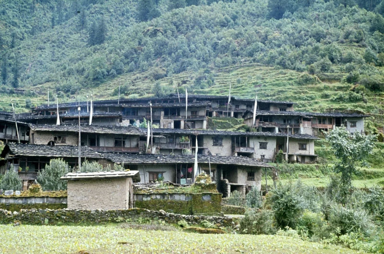
Helambu Trek
An 8-day teahouse loop from Sundarijal over the Shivapuri ridge, Kutumsang and Tharepati to the Yolmo villages of Melamchigaon, Tarke Ghyang and Sermathang, close to Kathmandu.
- दिन8
- अधिकतम ऊँचाई3,650 मी
- दूरी73.2 किमी
- चढ़ाई5,145 मी
- कठिनाईमध्यम
- सबसे अच्छे महीनेMar–May, Oct–Nov
- परमिट3
इस यात्रा-कार्यक्रम के साथ ट्रिप की योजना बनाएँHelambu Trek के लिए पार्टनर खोजेंहफ़्ते के अनुसार प्रस्थान देखें
फ़ोटो: Gerd Eichmann · CC BY-SA 4.0
सूचनाHelambu: not on the flooded Trishuli corridor, but check Langtang links
This route runs from Sundarijal to Melamchi and does not use the Syabrubesi or Trishuli road that the 26 August 2026 Langtang Lirung flood damaged (ICIMOD). No source we found reports damage on the Helambu trail itself.
If you plan to combine Helambu with Langtang or Gosaikunda (for example by the Tharepati link), or to reach Syabrubesi by road, read the Langtang advisory first: Syabrubesi, the usual Langtang road-head, is reported destroyed or closed as a trekking gateway, with the bridge to it swept away; restoration depends on the Betrawati highway reopening. The Trishuli Bazaar-Betrawati-Dhunche road was reported still closed for repair as of 21 September. A light-vehicle track has reopened, and agencies projected the remaining gaps passable no earlier than mid-October; that is a projection, not an official date.
Check current trail conditions with your trekking agency before booking.
स्थिति की जाँच 2026-10-19 को हुई।
स्रोत: ICIMOD: Kyirong-Rasuwa flood, 26 August 2026 · Nepal Pyramids: Langtang Valley trek update after the 2026 flooding
अंग्रेज़ी में दिखाया गया — अभी अनुवाद नहीं हुआ।
यह यात्रा-कार्यक्रम ड्राफ़्ट है और अभी सत्यापित नहीं हुआ है। चरणों की पुष्टि हमेशा अपने गाइड से करें।
Written by FindTrekkingPartner teamFindTrekkingPartner team द्वारा समीक्षितहम समीक्षा कैसे करते हैंFindTrekkingPartner
Helambu Trek नेपाल के Langtang क्षेत्र में 8 दिन का ट्रेक है, जो 3,650 मीटर तक चढ़ता है। विदेशी ट्रेकर FindTrekkingPartner पर अपनी तारीखों, बजट और रफ़्तार के साथ ट्रिप पोस्ट करके इसके लिए पार्टनर खोज सकते हैं। मैच तब तक निजी रहते हैं जब तक दोनों ट्रेकर सहमत न हों, और सेवा मुफ़्त है। मध्यम दरों पर लाइसेंस प्राप्त गाइड का खर्च चार ट्रेकर के साझा करने पर 8 दिनों में प्रति व्यक्ति लगभग USD 50 है, जबकि अकेले एक ट्रेकर के लिए USD 200। सबसे अच्छे मौसम Mar–May, Oct–Nov हैं। यहां व्यवहार में लाइसेंस प्राप्त गाइड ज़रूरी है: 2026 के ऑपरेटरों के अनुसार नेपाल पर्यटन बोर्ड का अप्रैल 2023 का नियम राष्ट्रीय उद्यानों और संरक्षण क्षेत्रों की चौकियों पर लागू किया जाता है, जिसमें लांगटांग सबसे सख़्त है और अन्नपूर्णा भी जांच करता है (19 अक्टूबर 2026 को जांचा गया)। पंजीकृत एजेंसी के माध्यम से गाइड रखें और उनसे पुष्टि करें। अंतिम सत्यापन: 21 अक्टूबर 2026। स्रोत: नेपाल पर्यटन बोर्ड, DNPWC, आव्रजन विभाग।
स्रोत:Department of Immigration, NepalNepal Tourism BoardDepartment of National Parks and Wildlife Conservation
Helambu Trek के लिए पार्टनर खोजें
- Helambu Trek के लिए पार्टनर खोजेंअभी कोई खुली ट्रिप नहीं
- Langtang Valley Trek के लिए पार्टनर खोजेंअभी कोई खुली ट्रिप नहीं
- Gosaikunda Lake Trek के लिए पार्टनर खोजें2 खुली ट्रिप
- Tamang Heritage Trail के लिए पार्टनर खोजेंअभी कोई खुली ट्रिप नहीं
परिचय
Sundarijal से शुरू8 दिन · अधिकतम 3,650 मी
सबसे अच्छा मौसम: Mar–May, Oct–Nov · परमिट: Shivapuri Nagarjun National Park entry permit, Langtang National Park entry permit, TIMS card where required
The Helambu trek is an 8-day loop through the hill villages north-east of Kathmandu, home of the Yolmo (Hyolmo) people, with a high point at Tharepati at about 3,650 m. It starts with a short drive to Sundarijal at the edge of the Kathmandu Valley, climbs through Shivapuri Nagarjun National Park to Chisapani, follows the ridge to Kutumsang and Tharepati, descends to Melamchigaon and Tarke Ghyang, and ends at Sermathang and Melamchi Bazaar before the drive back. The route covers about 90 km on foot with about 6,700 m of climbing and uses simple lodges every night, so no camping is needed. It is a moderate trek with steep stretches and long days, and no restricted-area permit is needed, only the national park permits. March to May and October to November are the best months, and winter is possible at low altitude. It suits first-time trekkers who want a short, cultural walk.
What the trek is like
From Sundarijal, the trail climbs steep stone steps beside a water pipeline into oak and rhododendron forest, then follows the Shivapuri ridge to Chisapani, a ridge village with long views of the Himalaya on clear mornings. Beyond Gul Bhanjyang and Kutumsang, the path climbs into fir and rhododendron forest to the Tharepati ridge, with views of Langtang Lirung and the Jugal range. It then descends to the Yolmo villages, with stone houses, mani walls and monasteries, and drops through apple orchards and terraces to Sermathang and Melamchi Bazaar. Most of the walk is on footpaths, with a few road crossings.
Highlights
- Tharepati, a high ridge with panoramic views of Langtang Lirung and the Jugal range
- Melamchigaon and Tarke Ghyang, Yolmo villages with gompas and mani walls
- Sermathang, known for its monastery and apple orchards
- Forest walks through Shivapuri Nagarjun National Park
- Short access from Kathmandu, with no flights
Permits and rules
You need the Shivapuri Nagarjun National Park entry permit at Sundarijal, the Langtang National Park entry permit for the higher section from Kutumsang on, and a TIMS card where the local office asks for it. Helambu is not a restricted area. The Nepal Tourism Board April 2023 rule requires foreign trekkers to use a licensed guide in national parks and conservation areas, and 2026 operator reports say checkpoints enforce it in Annapurna (ACAP), Langtang (the strictest) and most other parks, but not in Khumbu, where the municipality opted out (checked 19 October 2026). See the guide rule by region. Fees differ for foreigners, SAARC nationals and Nepalis, so ask for current amounts and check them with the park offices or the Department of National Parks and Wildlife Conservation.
Best season
March to May and October to November are the best months, with clear views in autumn and rhododendron in spring. Winter is cold but clear and quieter, with snow above Kutumsang. The monsoon has leeches, rain and landslides, and the 2021 floods on the Melamchi river damaged the valley, so check road conditions at the end of the trek.
Altitude
The highest point is Tharepati at about 3,650 m, and most of the trek stays between 1,400 m and 2,600 m. The climb from Kutumsang (about 2,470 m) to Tharepati is steady, and most people do not feel altitude sickness, but sleep at Melamchigaon or Tarke Ghyang if you have a headache. Never ascend with symptoms, and descend if they worsen.
Getting there and away
Take a bus or jeep from Kathmandu to Sundarijal, about an hour, and walk from there. At the end, drive from Melamchi Bazaar to Kathmandu in about 3 to 4 hours. Some trekkers use a jeep for part of the first or last section, and jeeps also serve Chisapani and Kutumsang in places. Landslides can close the Melamchi road in the monsoon.
Lodges, food and costs
Lodges at Chisapani, Kutumsang, Tharepati, Melamchigaon, Tarke Ghyang and Sermathang offer dal bhat, noodles, eggs and tea in simple rooms with blankets. Facilities are basic, and prices rise with altitude. Bring cash for the whole trek, because there are no machines beyond Sundarijal and Melamchi.
Packing list
Broken-in boots, waterproof layers, a warm jacket, a sleeping bag rated to about minus 5 C, hat and gloves, sunglasses, sun cream, trekking poles, a headlamp, water purification and a first-aid kit. In winter and early spring add a down jacket and in summer leech socks.
Who this trek suits and how to prepare
The trek suits first-time trekkers and anyone with limited time. The days are long at 6 to 9 hours, with steep ups and downs, so prepare with hill walks, stair training and some days with a loaded pack. No technical skills are needed.
The plan at a glance
Day 1 walks from Sundarijal to Chisapani and day 2 to Kutumsang. Day 3 climbs to Tharepati and day 4 descends to Melamchigaon. Day 5 walks to Tarke Ghyang and day 6 to Sermathang. Day 7 descends to Melamchi Bazaar and day 8 drives to Kathmandu.
Extensions
From Tharepati you can continue over the Laurebina La, at about 4,600 m, to Gosaikunda and Dhunche, a trek of three to four more days that joins Langtang. You can also add a day at Tarke Ghyang or Melamchigaon, or walk from Sermathang to Melamchi Bazaar by the lower trail.
Practical tips from the trail
- Walking times in the day plan are estimates from distance and climb, checked against operator itineraries; real times differ with pace, load and weather.
- Take rain gear even in autumn, since afternoon cloud is common.
- Start early on the long days to Kutumsang and Tharepati.
- Carry cash and small notes, as villages have no machines.
- Respect monasteries and walk clockwise around mani walls.
- Check the weather before leaving Kutumsang, because snow can block the ridge in winter.
Responsible trekking
Take rubbish out, use filtered water, buy from local families and respect Yolmo customs. Do not give sweets or money to children.
मुख्य आकर्षण
- Tharepati ridge at about 3,650 m, with views of the Langtang range
- Yolmo (Hyolmo) villages and monasteries at Melamchigaon, Tarke Ghyang and Sermathang
- Shivapuri Nagarjun National Park forest above Sundarijal
- Rhododendron, oak and fir forest and apple orchards
- A short trek that starts and ends within a day of Kathmandu
रूट मैप
रूट डेटा OpenStreetMap से है, हमारी टीम ने अभी जाँचा नहीं है। इसे प्लानिंग के लिए इस्तेमाल करें, नेविगेशन के लिए नहीं।
दिन-ब-दिन
A long ridge day from Chisapani to Kutumsang at about 2,470 m via Gul Bhanjyang, about 17 km with 1,500 m of climbing and 1,200 m of descent, taking 7.5 to 9 hours. The trail follows the Shivapuri ridge and crosses forested hills and farm villages, with road crossings in places. Gul Bhanjyang has lodges for lunch, and the route enters Langtang National Park after the checkpost. Kutumsang is a Yolmo and Tamang village with a small gompa and lodges. Rest and watch the sunset.
आप पिछली रात से 1,180 मी ऊँचाई पर सोएँगे, जो 500 मी की सामान्य सीमा से ज़्यादा है। धीरे चलें, खूब पानी पिएँ और सिरदर्द या मतली पर नज़र रखें।
Climb from Kutumsang to Tharepati at about 3,650 m, about 10 km with a climb of 1,330 m, taking 5.5 to 7 hours. The trail rises through fir and rhododendron forest to the ridge, with the route opening onto meadows and views of Langtang Lirung and the Jugal range. Tharepati is a high saddle with a few lodges and cold, windy nights. Put on warm layers early, eat well and drink plenty of water. The altitude is the highest of the trek, so watch for any headache.
A short descent from Tharepati to Melamchigaon at about 2,540 m, about 5 km with a drop of 1,170 m, taking 2 to 3 hours. The trail drops steeply through fir forest and rhododendron, with views of the Melamchi valley opening ahead. Melamchigaon is a Yolmo village of stone houses, mani walls and a gompa, with lodges and apple orchards. The air feels warmer after Tharepati. Spend the afternoon exploring the village and the monastery, and rest your knees. Apple and cheese may be on offer.
Walk from Melamchigaon to Tarke Ghyang at about 2,580 m, about 6 km with 680 m of climbing and 650 m of descent, taking 3 to 4 hours. The trail crosses the Melamchi Khola on a bridge and climbs to the village, which is known for its large monastery, long mani wall and traditional houses. Tarke Ghyang has lodges and shops, and it is a good place to learn about Yolmo culture. Walk around the village in the afternoon and visit the gompa, respecting local customs.
A moderate walk from Tarke Ghyang to Sermathang at about 2,580 m, about 10 km with 700 m of climbing and 670 m of descent, taking 4 to 5 hours. The trail follows the ridge through forest, meadows and small villages, with views of terraced hills and the Melamchi valley. Sermathang is known for its monastery, its apple orchards and its views, and it has simple lodges. Use the afternoon to rest, wash clothes and watch the sunset over the hills. Take poles for the steep stone steps.
A long descent from Sermathang to Melamchi Bazaar at about 820 m, about 17 km with a drop of 1,890 m, taking 5 to 7 hours. The trail follows footpaths and sections of the road down through forest, farms and villages, with the air getting warmer and more humid. Use poles to spare your knees. Melamchi Bazaar is a busy town on the river, rebuilt after the 2021 floods, with hotels and shops. Rest, shower and celebrate the last day of walking.
आप पिछली रात से 580 मी ऊँचाई पर सोएँगे, जो 500 मी की सामान्य सीमा से ज़्यादा है। धीरे चलें, खूब पानी पिएँ और सिरदर्द या मतली पर नज़र रखें।
Drive from Melamchi Bazaar to Kathmandu, about 3 to 4 hours by jeep or bus along the Melamchi road. The road can be slow in places, and landslides in the monsoon can cause delays. Leave early to arrive in Kathmandu in the afternoon, and keep a spare day in the schedule if possible. Back in the hotel, shower, repack and celebrate with a good dinner. Tip your guide and porters according to your agency's guidelines. Keep your passport and permit copies in your hand luggage.
अनुकूलन
रात-दर-रात सोने की ऊँचाई। लाल बार पिछली रात से 500 मी से ज़्यादा चढ़ाई दिखाते हैं; आराम के दिन चिह्नित हैं।
- सोने की ऊँचाई
- 500 मी से ज़्यादा बढ़ोतरी
- आराम का दिन
कितना खर्च होता है
प्रति व्यक्ति कुल अनुमानित खर्च: ऊँचाई के हिसाब से लॉज और खाना, परिवहन, परमिट, और गाइड व पोर्टर। जितने ज़्यादा ट्रेकर्स गाइड और पोर्टर साझा करते हैं, हर व्यक्ति उतना कम देता है। अक्टूबर 2026 तक।
| स्टाइल | 1 ट्रेकर | 2 ट्रेकर साथ में | 4 ट्रेकर साथ में |
|---|---|---|---|
| किफ़ायती | $320–$480* | $240–$360* | $200–$300* |
| मध्यम बजट | $470–$720* | $340–$510* | $300–$450* |
| आरामदायक | $530–$790* | $450–$670* | $410–$610* |
गाइड साझा करें, पैसे बचाएँ
मध्यम श्रेणी में अकेला ट्रेकर लगभग $470–$720 देता है; एक गाइड और दो पोर्टर साझा करने वाले चार ट्रेकर्स हर एक लगभग $300–$450 देते हैं (ऊपरी सीमा पर 38% कम)।
साथ में 2 ट्रेकर्स के लिए ब्योरा
| मद | किफ़ायती | मध्यम बजट | आरामदायक |
|---|---|---|---|
| लॉज और खाना | $120–$190 | $160–$260 | $210–$330 |
| परमिट | $40–$50 | $40–$50 | $40–$50 |
| गाइड | $80–$120 | $80–$120 | $80–$120 |
| पोर्टर | — | $50–$90 | $100–$180 |
बजट में सार्वजनिक परिवहन है और पोर्टर नहीं; मध्यम में दो ट्रेकर्स के बीच एक पोर्टर और निजी वाहन है; आरामदायक में हर ट्रेकर को एक पोर्टर मिलता है। जहाँ गाइड ज़रूरी है या स्टाइल मध्यम या आरामदायक है, वहाँ गाइड शामिल है।
प्रति रात लॉज और खाना (कमरा और एक दाल भात)
3 रातें Below 2,500 m: कमरा $2–$9, दाल भात $4–$7 · 4 रातें 2,500 to 3,800 m: कमरा $3–$7, दाल भात $4–$7
परमिट शुल्क (आधिकारिक स्रोत)
शामिल नहीं
इनके लिए कोई प्रकाशित कीमत नहीं मिली: Kathmandu to Sundarijal; Melamchi to Kathmandu bus or jeep। * से चिह्नित कुल में ये शामिल नहीं हैं; अपनी एजेंसी से पूछें।
खर्च के स्रोत
- PriceNepal: Nepal Travel Cost Guide 2026 (2026-05-14)
- Third Rock Adventures: Nepal trek budget planner (2026-05-09)
- Himalayan Partner: Guide and porter price in Nepal 2026 (2026-02-10)
- Shikhar Adventure: Annapurna Circuit trek cost (2026-02-03)
- Third Rock Adventures: Kathmandu to Syabrubesi (2026-10-18)
ऑपरेटर गाइड से अनुमान, कोटेशन नहीं। टिप, बीमा, गियर और काठमांडू के होटल शामिल नहीं हैं; USD प्लेटफ़ॉर्म की विनिमय दर पर।
फ़ोटो
अक्सर पूछे जाने वाले सवाल
You need the Shivapuri Nagarjun National Park permit and the Langtang National Park permit for the higher section. Helambu is not a restricted area. Ask for current fees.
The Nepal Tourism Board April 2023 rule requires foreign trekkers to use a licensed guide in national parks and conservation areas, and 2026 operator reports say checkpoints enforce it in Annapurna (ACAP), Langtang (the strictest) and most other parks, but not in Khumbu, where the municipality opted out (checked 19 October 2026). Confirm with a registered agency. A guide is helpful for route finding and permits.
Eight days from Kathmandu on this plan, including seven days of walking and a drive back. It can be done in 5 to 6 days by skipping some stages.
About 3,650 m according to the elevation model, while sources quote between about 3,600 and 3,700 m. It is the highest point of the trek.
March to May and October to November. Winter is cold but clear at low altitude, and the monsoon has leeches and landslides.
The Yolmo, or Hyolmo, are a Buddhist community of Helambu, related to Tibetan and Sherpa culture, known for their monasteries and for apples.
Yes. From Tharepati you can cross the Laurebina La to Gosaikunda and Dhunche, adding about three to four days.
स्रोत
- Helambu Circuit Trek, 7 days (Himalayan Local Guide)
- Helambu Circuit Trek itinerary (Everest Trekking Routes)
- Helambu (Wikipedia)
- Langtang National Park (Wikipedia)
- Shivapuri Nagarjun National Park (Wikipedia)
- Department of National Parks and Wildlife Conservation, Nepal
- Nepal Tourism Board
- Himalayan Rescue Association
- OpenStreetMap (elevation tags of villages and ridges)
ट्रेल के किनारे
रूट के हर दिन ठहरने की जगहें, चिकित्सा सहायता, पानी और देखने लायक जगहें।
1. Sundarijal → Chisapani
- Sundarijal Swastha Chauki · चिकित्सा · 1,686 मी
- Shivapuri Jungle View Resort · ठहरने की जगहें · 2,134 मी
- Hotel B.B.C. · ठहरने की जगहें · 2,172 मी
- Sunrise Hotel · ठहरने की जगहें · 2,168 मी
- Hotel Annapurna Mountain View · ठहरने की जगहें · 2,174 मी
Show all 11 places
- Hotel Mount D.J. · ठहरने की जगहें · 1,709 मी
- Sundarijal Swastha Chauki · चिकित्सा · 1,686 मी
- Hotel Karma and Restaurant · ठहरने की जगहें · 1,670 मी
- City View Restaurant & Lodge · ठहरने की जगहें · 1,973 मी
- City View Guest House & Restaurant · ठहरने की जगहें · 1,972 मी
- Safal top rest point, hotel anf lodge · ठहरने की जगहें · 2,006 मी
- Aman hotel · ठहरने की जगहें · 2,011 मी
- Shivapuri Jungle View Resort · ठहरने की जगहें · 2,134 मी
- Hotel B.B.C. · ठहरने की जगहें · 2,172 मी
- Sunrise Hotel · ठहरने की जगहें · 2,168 मी
- Hotel Annapurna Mountain View · ठहरने की जगहें · 2,174 मी
2. Chisapani → Kutumsang
- Dorje Lakpa Hotel · ठहरने की जगहें · 2,163 मी
- Viewpoint · व्यूपॉइंट · 2,149 मी
- Himalayan Inn · ठहरने की जगहें · 2,488 मी
- Mountain View Lodge & Resort · ठहरने की जगहें · 2,480 मी
- Kutumsang Health Centre · चिकित्सा · 2,478 मी
- Aana yangri · ठहरने की जगहें · 2,475 मी
Show all 22 places
- Dorje Lakpa Hotel · ठहरने की जगहें · 2,163 मी
- Hotel Trekkers paradise and Mountain View Restaurant · ठहरने की जगहें · 2,140 मी
- Hotel Chisopani · ठहरने की जगहें · 2,140 मी
- Chisopani · ठहरने की जगहें · 2,140 मी
- Viewpoint · व्यूपॉइंट · 2,149 मी
- Mount Bliss · ठहरने की जगहें · 2,138 मी
- Himalayan Vista · ठहरने की जगहें · 2,131 मी
- Hotel Everest View Point · ठहरने की जगहें · 2,045 मी
- Hotel Lama · ठहरने की जगहें · 1,796 मी
- Lama Guest House · ठहरने की जगहें · 1,847 मी
- Namaste Hotel · ठहरने की जगहें · 2,155 मी
- Thotung Top · ठहरने की जगहें · 2,309 मी
- Sunrise Lodge · ठहरने की जगहें · 2,276 मी
- Thodong Lama Lodge · ठहरने की जगहें · 2,275 मी
- Green hill view · ठहरने की जगहें · 2,268 मी
- Tashi Delek Hotel · ठहरने की जगहें · 2,267 मी
- Himalayan New Lodge & Restaurant · ठहरने की जगहें · 2,140 मी
- New Gosainkunda Lodge & Restaurant · ठहरने की जगहें · 2,137 मी
- Himalayan Inn · ठहरने की जगहें · 2,488 मी
- Mountain View Lodge & Resort · ठहरने की जगहें · 2,480 मी
- Kutumsang Health Centre · चिकित्सा · 2,478 मी
- Aana yangri · ठहरने की जगहें · 2,475 मी
3. Kutumsang → Tharepati
- Yak Hotel & Guest House · ठहरने की जगहें · 2,464 मी
- Gosaikunda Hotel · ठहरने की जगहें · 2,473 मी
- Langtang Lirung View · ठहरने की जगहें · 2,469 मी
- Hotel Namaste · ठहरने की जगहें · 2,474 मी
4. Tharepati → Melamchigaon
- Langtang Lirung View · ठहरने की जगहें · 3,646 मी
- Hotel Thasi Delek · ठहरने की जगहें · 3,637 मी
- Sumchho Top Lodge (3642m) · ठहरने की जगहें · 3,642 मी
5. Melamchigaon → Tarke Ghyang
- Himalaya Lama Lodge · ठहरने की जगहें · 2,543 मी
- Dhingha Rangjen Community Health Service Center · चिकित्सा · 2,515 मी
- Eco Friendly Home & Lodge · ठहरने की जगहें · 2,537 मी
- Hotel Eco Friendly · ठहरने की जगहें · 2,513 मी
- Zambala Guest House & Restaurant · ठहरने की जगहें · 1,992 मी
6. Tarke Ghyang → Sermathang
- Hotel Tarkeyghyang · ठहरने की जगहें · 2,553 मी
- Hotel Tarkeghyang · ठहरने की जगहें · 2,556 मी
- Hotel Yangri Peak · ठहरने की जगहें · 2,564 मी
- Ama Yangri Base Camp · ठहरने की जगहें · 3,173 मी
Show all 5 places
- Hotel Tarkeyghyang · ठहरने की जगहें · 2,553 मी
- Hotel Tarkeghyang · ठहरने की जगहें · 2,556 मी
- Hotel Yangri Peak · ठहरने की जगहें · 2,564 मी
- Buddha Lodge · ठहरने की जगहें · 2,570 मी
- Ama Yangri Base Camp · ठहरने की जगहें · 3,173 मी
7. Sermathang → Melamchi
- Keureni Swasthe Ikai · चिकित्सा · 1,401 मी
- Dubachaur swasthe chauki · चिकित्सा · 1,553 मी
- Melamchi hotel · ठहरने की जगहें · 825 मी
Show all 7 places
- Keureni Swasthe Ikai · चिकित्सा · 1,401 मी
- Dubachaur swasthe chauki · चिकित्सा · 1,553 मी
- Melamchi polyclinic and research center · चिकित्सा · 851 मी
- Jaraayetar Ayurveda Aushadhalaya · चिकित्सा · 866 मी
- Melamchi phc · चिकित्सा · 851 मी
- Melamchi hotel · ठहरने की जगहें · 825 मी
- Melamchi hospital · चिकित्सा · 826 मी
8. Melamchi → Kathmandu
- त्रिभुवन अन्तर्राष्ट्रीय विमानक्षेत्र · हवाई अड्डे और परिवहन · 1,340 मी
अंतिम बार 21 अक्टू॰ 2026 को सत्यापितपुरानी जानकारी की रिपोर्ट करें